Category:RAF Andrews Field
| Object location | | View all coordinates using: OpenStreetMap |
|---|
former Air Force field located in England  | |||||
| Upload media | |||||
| Instance of | |||||
|---|---|---|---|---|---|
| Location |
| ||||
| Operator |
| ||||
| Inception |
| ||||
| Dissolved, abolished or demolished date |
| ||||
| Replaced by | |||||
 | |||||
English: RAF Andrews Field near Great Saling, Essex, was used by the Royal Air Force (RAF) and USAAF until the end of World War II. For civilian aviation use since 1946, see category: Andrewsfield Airport.
Subcategories
This category has only the following subcategory.
Media in category "RAF Andrews Field"
The following 25 files are in this category, out of 25 total.
-
 1st Pathfinder Squadron - Crew Photo.jpg 640 × 508; 74 KB
-
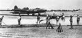
 322d Bomb Group B-26 Marauder 41-31773 (cropped).jpg 1,170 × 659; 168 KB
-
 322d Bomb Group B-26 Marauder 41-31773.jpg 1,303 × 872; 244 KB
-
 322dbg-b26.jpg 600 × 463; 59 KB
-
 95bg-b17andrews.jpg 600 × 280; 42 KB
-

-

-

-

-
 Andrewsfieldphoto-26jul48.png 600 × 493; 352 KB
-
 B-26-322bg-andfld-1944.jpg 1,267 × 867; 282 KB
-
 Grodynski Brigade Image 17.jpg 1,697 × 1,136; 210 KB
-
 RAF Andrews Field - 3 July 1949 5372.jpg 1,668 × 1,726; 614 KB
-
 RAF Andrews Field - 3 July 1949 5373.jpg 1,662 × 1,729; 600 KB
-
 RAF Andrews Field - 3 July 1949 5412.jpg 1,670 × 1,722; 550 KB
-
 RAF Andrews Field - 3 July 1949 5419.jpg 1,666 × 1,734; 574 KB
-
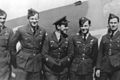
 RAF Andrews Field - 322d Bombardment Group - 3 Airmen.jpg 1,316 × 866; 232 KB
-
 RAF Andrews Field - 322d Bombardment Group - B-26 Marauder 41-31814 2.jpg 1,312 × 861; 201 KB
-
 RAF Andrews Field - 322d Bombardment Group - B-26 Marauder 41-31814.jpg 1,318 × 862; 193 KB
-
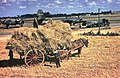 RAF Andrews Field - 322d Bombardment Group - Farmers.jpg 1,273 × 828; 532 KB
-
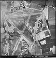
 RAF Andrews Field - 4 September 1943 - Airfield.jpg 1,704 × 1,350; 439 KB
-
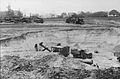 RAF Andrews Field - Construction Photo.jpg 5,486 × 3,597; 2.44 MB
-
 Andrews Field Hangar^ - geograph.org.uk - 570307.jpg 640 × 426; 108 KB
-
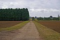 Andrews Field Peri - geograph.org.uk - 577168.jpg 640 × 426; 95 KB
-


.jpg)


