Category:RAF Bury St Edmunds
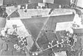
English: The airfield near Bury St Edmunds, Suffolk, was used as RAF Bury St Edmunds by the RAF and USAAF until the end of World War II. The remaining facility in civilian use is now known as Rougham Airfield.
| Object location | | View all coordinates using: OpenStreetMap |
|---|
 | |||||
| Upload media | |||||
| Location |
| ||||
|---|---|---|---|---|---|
 | |||||
Subcategories
This category has the following 3 subcategories, out of 3 total.
R
- Rougham Fly-In 2021 (268 F)
- Rougham Wings Wheels And Steam 2008 (323 F)
Media in category "RAF Bury St Edmunds"
The following 48 files are in this category, out of 48 total.
-
 Bseairfield-6jun1955.jpg 600 × 403; 64 KB
-
 Bseairfield-6jun1955.png 600 × 403; 275 KB
-
 94bg-42-39775.jpg 600 × 354; 51 KB
-
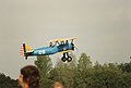
 Byplanes - 49997575488.jpg 5,380 × 3,669; 11.08 MB
-
 Byplanes - 49997575858.jpg 5,244 × 3,492; 8.98 MB
-
 Byplanes - 49998099231.jpg 5,483 × 3,702; 9.96 MB
-
 Byplanes - 49998101316.jpg 5,475 × 3,671; 11.57 MB
-
 Byplanes - 49998350627.jpg 6,779 × 4,594; 14.43 MB
-
 Byplanes - 49998353277.jpg 4,903 × 3,367; 9.76 MB
-
 Byplanes.jpg 5,266 × 3,494; 9.65 MB
-
 Jeep (Rougham Airfield 1997).jpg 6,592 × 4,416; 15.91 MB
-
 Martin B-26B-3 Marauder 41-17973.jpg 1,411 × 911; 194 KB
-

-

-

-

-

-
 Military Vehicle.jpg 6,576 × 4,448; 17.27 MB
-
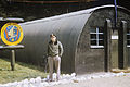 RAF Bury St Edmunds - 333d Bomb Squadron Orderly Room.jpg 5,374 × 3,571; 2.39 MB
-
 RAF Bury St Edmunds - 94th Bombardment Group - B-17 43-39096.jpg 5,493 × 3,543; 4.05 MB
-
 RAF Bury St Edmunds - 94th Bombardment Group - B-17 44-8158.jpg 5,370 × 3,586; 4.4 MB
-
 RAF Bury St Edmunds - 94th Bombardment Group - B-17 44-83494.jpg 5,463 × 3,538; 3.83 MB
-
 RAF Bury St Edmunds - 94th Bombardment Group - B-17 taking off.jpg 5,468 × 3,564; 4.12 MB
-
 RAF Bury St Edmunds - 94th Bombardment Group - B-17s on Hardstands.jpg 1,427 × 867; 198 KB
-
 RAF Bury St Edmunds - 94th Bombardment Group - B-17s on taxiway.jpg 5,387 × 3,581; 5.26 MB
-
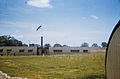
 RAF Bury St Edmunds - 94th Bombardment Group - No 1 Hangar.jpg 5,399 × 3,564; 2.48 MB
-
 RAF Bury St Edmunds - 94th Bombardment Group Headquarters.jpg 5,440 × 3,582; 3.18 MB
-

-
 RAF Bury St Edmunds - Crew Reading Room.jpg 1,301 × 984; 226 KB
-
 RAF Bury St Edmunds - General Arnold Visit.jpg 6,465 × 3,760; 3 MB
-
 Rougham Air Event 1997-7.jpg 5,636 × 3,744; 11.95 MB
-
 Spitfire (Rougham Airfield 1997).jpg 5,349 × 3,617; 11.68 MB
-
 Spitfire - 49997576443.jpg 5,766 × 3,748; 11.33 MB
-
 Spitfire - 49997576713.jpg 6,688 × 4,336; 12.7 MB
-
 Spitfire - 49998352387.jpg 6,671 × 4,368; 12.95 MB
-
 Super Fortress - 49997574868.jpg 5,230 × 3,391; 6.97 MB
-
 Super Fortress - 49997578563.jpg 5,224 × 3,441; 4.47 MB
-
 Super Fortress - 49997579238.jpg 5,758 × 3,745; 7.61 MB
-
 Super Fortress - 49998096041.jpg 6,880 × 4,544; 12.85 MB
-
 Super Fortress - 49998096771.jpg 5,779 × 3,884; 10.84 MB
-
 Super Fortress - 49998347562.jpg 6,816 × 4,576; 13.89 MB
-
 Super Fortress - 49998348072.jpg 5,563 × 3,566; 4.86 MB
-
 Super Fortress - 49998351157.jpg 5,884 × 3,951; 10.5 MB
-
 Super Fortress - 49998351352.jpg 5,342 × 3,544; 8.46 MB
-
 Super Fortress - 49998351552.jpg 5,489 × 3,681; 8.25 MB
-
 Super Fortress - 49998351807.jpg 5,823 × 3,971; 11.3 MB
-
 Super Fortress - 49998352787.jpg 4,964 × 3,184; 4.54 MB
-
 Super Fortress.jpg 5,353 × 3,598; 9.21 MB


.jpg)

.jpg)
.jpg)
.jpg)
.jpg)
.jpg)


.jpg)


