Category:RAF Metheringham
| Object location | | View all coordinates using: OpenStreetMap |
|---|
Royal Air Force station  | |||||
| Upload media | |||||
| Instance of |
| ||||
|---|---|---|---|---|---|
| Location |
| ||||
| Operator | |||||
| Inception |
| ||||
| Dissolved, abolished or demolished date |
| ||||
| Elevation above sea level |
| ||||
 | |||||
Media in category "RAF Metheringham"
The following 19 files are in this category, out of 19 total.
-
 Bombing up 106 Squadron Lancaster WWII IWM CH 12541.jpg 800 × 665; 52 KB
-
 Former RAF Metheringham - geograph.org.uk - 110862.jpg 640 × 480; 364 KB
-
 Former RAF Metheringham WWII Airfield - geograph.org.uk - 98627.jpg 480 × 640; 141 KB
-
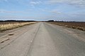 Former runway of RAF Metheringham - geograph.org.uk - 3384439.jpg 2,256 × 1,504; 1.39 MB
-
 Former runway, RAF Metheringham - geograph.org.uk - 4648384.jpg 640 × 480; 55 KB
-
 RAF Metheringham - geograph.org.uk - 837467.jpg 640 × 427; 85 KB
-
 RAF Metheringham Gymnasium.jpg 2,240 × 1,488; 2.25 MB
-
 RAF Metheringham memorial - geograph.org.uk - 2373149.jpg 640 × 480; 161 KB
-
 RAF Metheringham Memorial Garden.jpg 2,240 × 1,488; 2.44 MB
-
 RAF Metheringham memorial on former runway - geograph.org.uk - 3181943.jpg 3,872 × 2,592; 2.38 MB
-
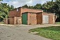 RAF Metheringham Standby Generator House.jpg 2,240 × 1,488; 2.66 MB
-
 RAF Metheringham Synthetic Bombing Trainer.jpg 2,240 × 1,488; 2.2 MB
-
 Royal Air Force 1939-1945- Bomber Command CH12540.jpg 676 × 800; 63 KB
-
 Royal Air Force Bomber Command, 1942-1945. CH12543.jpg 2,108 × 1,772; 821 KB
-
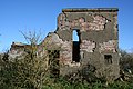 Ruined Control Tower RAF Metheringham - geograph.org.uk - 2148654.jpg 3,456 × 2,304; 4.69 MB
-
 Ruined Control Tower RAF Metheringham - geograph.org.uk - 2148659.jpg 3,456 × 2,304; 4.26 MB
-
 Metheringham Airfield Visitor Centre - geograph.org.uk - 57792.jpg 640 × 480; 121 KB
-
 Not just an old runway - geograph.org.uk - 434025.jpg 640 × 480; 90 KB
-
 RAF Metheringham - geograph.org.uk - 406268.jpg 640 × 427; 60 KB


