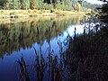
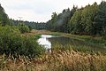
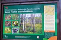
Category:Rašeliniště Černého rybníka
| Object location | | View all coordinates using: OpenStreetMap |
|---|
protected area in Czech Republic  | |||||
| Upload media | |||||
| Instance of | |||||
|---|---|---|---|---|---|
| Location | Hamr na Jezeře, Česká Lípa District, Liberec Region, Czechia | ||||
| Maintained by | |||||
| IUCN protected areas category | |||||
| Inception |
| ||||
| Area |
| ||||
 | |||||
Media in category "Rašeliniště Černého rybníka"
The following 8 files are in this category, out of 8 total.
-
 PP rašeliniště1.jpg 3,648 × 2,736; 3.55 MB
-
 PP rašeliniště2.jpg 3,648 × 2,736; 3.54 MB
-
 PP rašeliniště3.jpg 3,648 × 2,736; 3.53 MB
-
 Rašeliniště Černého rybníka 01.jpg 5,472 × 3,648; 3.39 MB
-
 Rašeliniště Černého rybníka 02.jpg 5,472 × 3,648; 5.02 MB
-
 Rašeliniště Černého rybníka 03.jpg 5,472 × 3,648; 5.37 MB
-
 Rašeliniště Černého rybníka 2021-06 01.jpg 5,063 × 3,375; 11.05 MB
-
 Černý rybník 4.jpg 3,648 × 2,432; 2.14 MB


