Category:Radio station in Gliwice
| Object location | | View all coordinates using: OpenStreetMap |
|---|
Polski: Radiostacja gliwicka
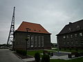
transmission tower in the Szobiszowice district of Gliwice, Upper Silesia, Poland    | |||||
| Upload media | |||||
| Instance of | |||||
|---|---|---|---|---|---|
| Part of |
| ||||
| Location | Gliwice, Silesian Voivodeship, Poland | ||||
| Has part(s) | |||||
| Heritage designation |
| ||||
| Inception |
| ||||
| Date of official opening |
| ||||
| Significant event |
| ||||
| Height |
| ||||
 | |||||
Media in category "Radio station in Gliwice"
The following 49 files are in this category, out of 49 total.
-
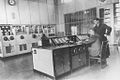
 Gleiwitzer Radiosender - im Inneren.JPG 2,304 × 1,728; 520 KB
-
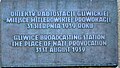 Glivice plaque.JPG 465 × 265; 168 KB
-
 Gliwice Budynki Radiostacji.JPG 3,600 × 2,600; 4.83 MB
-
 Gliwice Miejsce prowokacji.JPG 1,024 × 683; 94 KB
-
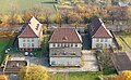
 Gliwice radio station buildings & garages 2018.jpg 3,124 × 2,082; 4.22 MB
-
 Gliwice radio station buildings 2018.jpg 3,200 × 2,392; 5.02 MB
-
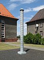 Gliwice radio station pole 2018.jpg 2,310 × 3,156; 5.28 MB
-
 Gliwice Radiostacja od ul. Tarnogorskiej.jpg 1,444 × 1,142; 554 KB
-
 Gliwice Radiostacja Wejscie polnocne.jpg 800 × 462; 81 KB
-
 Gliwice Radiostacja z 55 metra wiezy.jpg 800 × 496; 305 KB
-
 Gliwice Radiostacja zima.JPG 800 × 483; 272 KB
-
 Gliwice Radiostacja.jpg 800 × 575; 269 KB
-
 Gliwice Tarnogorska 129 relief 2018.jpg 3,000 × 2,000; 3.89 MB
-
 Gliwice, budynek przy radiostacji, ul. Tarnogórska 127, widok od pn..JPG 4,000 × 3,000; 3.06 MB
-
 Gliwice, budynek przy radiostacji, ul. Tarnogórska 127.JPG 4,000 × 3,000; 3.5 MB
-
 Gliwice, budynek przy radiostacji, ul. Tarnogórska 129, widok od pn..JPG 4,000 × 3,000; 2.97 MB
-
 Gliwice, budynek przy radiostacji, ul. Tarnogórska 129.JPG 3,000 × 4,000; 2.47 MB
-
 Gliwice, budynek przy radiostacji, ul. Tarnogórska 131.JPG 4,000 × 3,000; 2.68 MB
-
 Gliwice, tablica pamiątkowa w kompleksie radiostacji.JPG 4,000 × 3,000; 3.6 MB
-
 Gliwice, zabudowania radiostacji nocą.JPG 1,745 × 1,180; 375 KB
-
 Gliwice, zabudowania w kompleksie radiostacji (1).JPG 4,000 × 3,000; 3.54 MB
-
 Gliwice, zabudowania w kompleksie radiostacji (2).JPG 4,000 × 3,000; 3.39 MB
-
 Gliwice, zabytkowe wyposażenie radiostacji 01.JPG 1,745 × 1,180; 291 KB
-
 Kompleks zabudowań dawnej radiostacji z lat 1934-1936 (BUCHMANN).JPG 700 × 525; 311 KB
-
 Kompleks zabudowań dawnej radiostacji z lat 1934-1936 2 (BUCHMANN).JPG 700 × 525; 344 KB
-
 Kompleks zabudowań dawnej radiostacji z lat 1934-1936 3 (BUCHMANN).JPG 700 × 525; 284 KB
-
 Otoczenie radiostacji 01.JPG 4,608 × 3,456; 1.92 MB
-
 Otoczenie radiostacji 02.JPG 4,608 × 3,456; 1.5 MB
-
 Otoczenie radiostacji 05.JPG 4,608 × 3,456; 6.23 MB
-
 Provokado Gliwice (4826334429).jpg 2,048 × 1,536; 1.38 MB
-
 Radio station in Gliwice 1.jpg 2,592 × 1,456; 1.06 MB
-
 Radio station in Gliwice 2.jpg 2,592 × 1,456; 1,008 KB
-
 Radiostacja Gliwice Q597596.jpg 3,156 × 4,765; 8.36 MB
-
 Radiostacja Gliwicka hala prostowników.JPG 4,876 × 3,229; 2.64 MB
-
 Radiostacja gliwicka, wnętrze - Sender Gleiwitz, Innenraum 01.jpg 8,000 × 6,000; 8.47 MB
-
 Radiostacja gliwicka, wnętrze - Sender Gleiwitz, Innenraum 02.jpg 8,000 × 6,000; 5.93 MB
-
 Radiostacja gliwicka, wnętrze - Sender Gleiwitz, Innenraum 03.jpg 8,000 × 6,000; 8.78 MB
-
 Radiostacja gliwicka, wnętrze - Sender Gleiwitz, Innenraum 04.jpg 8,000 × 6,000; 8.44 MB
-
 Radiostacja gliwicka, wnętrze - Sender Gleiwitz, Innenraum 05.jpg 8,000 × 6,000; 8.21 MB
-
 Spokojne miejsce 01.JPG 4,608 × 3,456; 1.69 MB
-
 Teren radiostacji 02.JPG 4,608 × 3,456; 1.83 MB
-
 Teren radiostacji 05.JPG 4,608 × 3,456; 1.31 MB
-
 Teren radiostacji 06.JPG 4,608 × 3,456; 2.35 MB
-
 Trzy domy 01.JPG 4,608 × 3,456; 2.05 MB
-
 Trzy domy 02.JPG 4,608 × 3,456; 3.01 MB
-
 Trzy domy 03.JPG 4,608 × 3,456; 3.26 MB
-
 Trzy domy 04.JPG 4,608 × 3,456; 6.18 MB
-
 Widok z radiostacji w Gliwicach - panoramio.jpg 2,048 × 1,536; 1.14 MB
-
 Fuhrer durch Gleiwitz 1934 (3771219).jpg 2,709 × 2,685; 1.92 MB


.JPG)
.JPG)
.JPG)
.JPG)
.JPG)


.jpg)


.jpg)