Category:Rail transport maps of Puy-de-Dôme
Media in category "Rail transport maps of Puy-de-Dôme"
The following 6 files are in this category, out of 6 total.
-
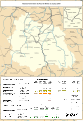
 Railway map of France - 63 - 1900 - fr - small.svg 705 × 1,020; 7.95 MB
-
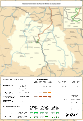
 Railway map of France - 63 - 1913 - fr - small.svg 705 × 1,020; 8.09 MB
-
 Railway map of France - 63 - 1930 - fr - small.svg 705 × 1,020; 8.1 MB
-
 Railway map of France - 63 - 1950 - fr - small.svg 705 × 1,020; 8.05 MB
-
 Railway map of France - 63 - 1980 - fr - small.svg 705 × 1,020; 8.03 MB
-
 Railway map of France - 63 - 2020 - fr - small.svg 705 × 1,020; 7.86 MB


