Category:Rail transport maps of Rutland
Media in category "Rail transport maps of Rutland"
The following 12 files are in this category, out of 12 total.
-
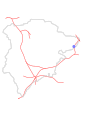
 B'ham-Peterborough Line Map.png 1,324 × 527; 954 KB
-
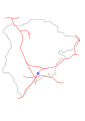
 Birmingham–Peterborough line.png 2,647 × 1,485; 3.17 MB
-
 Essendine Station.svg 744 × 1,052; 63 KB
-
 Manton Station.svg 744 × 1,052; 63 KB
-
 Morcott Station.svg 744 × 1,052; 63 KB
-
 Oakham Station.svg 744 × 1,052; 63 KB
-
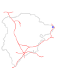
 Oakham–Kettering line.png 1,315 × 1,222; 1.02 MB
-
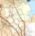 Rail transport infrastructure map - UK - East Midlands.svg 983 × 1,020; 6.31 MB
-
 Ryhall Station.svg 744 × 1,052; 63 KB
-
 Seaton Station.svg 744 × 1,052; 63 KB
-
 Uppingham Station.svg 744 × 1,052; 63 KB
-
 Whissendine Station.svg 744 × 1,052; 63 KB


