Category:Rail transport maps of Surrey
Media in category "Rail transport maps of Surrey"
The following 17 files are in this category, out of 17 total.
-
 Alton line.png 1,935 × 1,358; 2.02 MB
-
 Ascot-Guildford line.png 1,506 × 1,930; 2.52 MB
-
 Epsom Downs Branch.png 1,669 × 1,196; 1.22 MB
-
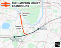 Hampton Court branch line.png 1,287 × 1,030; 891 KB
-
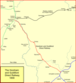
 New Guildford line.png 1,634 × 1,514; 2.69 MB
-
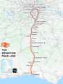 Brighton main line.png 1,797 × 2,374; 4.28 MB
-
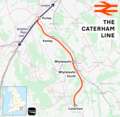 Caterham line.png 1,655 × 1,615; 1.5 MB
-
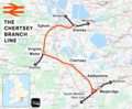 Chertsey branch line.png 1,685 × 1,386; 2.03 MB
-
 Cranleigh line.png 1,068 × 1,163; 83 KB
-
 Crossrail2 Greater London.png 1,385 × 1,056; 448 KB
-
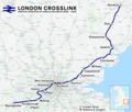 London Crosslink.png 2,353 × 1,992; 5.2 MB
-
 Oxted line.png 1,552 × 1,707; 2.6 MB
-
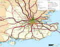 Rail transport infrastructure map - UK - South East England.svg 1,247 × 983; 8.83 MB
-
 Redhill–Tonbridge line.png 2,340 × 1,527; 2.92 MB
-
 Shepperton branch line.png 2,239 × 1,416; 2.24 MB
-
 Staines–Windsor line.png 1,808 × 1,417; 1.53 MB
-
 Tattenham Corner line.png 2,184 × 1,418; 1.76 MB


