Category:Rail transport maps of Warwickshire
Media in category "Rail transport maps of Warwickshire"
The following 35 files are in this category, out of 35 total.
-

-
 B&ojr.png 903 × 1,437; 94 KB
-
 B'ham-Peterborough Line Map.png 1,324 × 527; 954 KB
-
 Birmingham & West Mids Passenger Railway Map (no Metro).svg 1,304 × 1,039; 298 KB
-
 Birmingham & West Mids Passenger Railway Map.JPG 1,248 × 1,142; 472 KB
-
 Birmingham & West Mids Passenger Railway Map.svg 1,374 × 1,056; 315 KB
-
 BirminghamLoop.svg 2,060 × 1,600; 51 KB
-
 Birmingham–Peterborough line.png 2,647 × 1,485; 3.17 MB
-
 Chiltern Main Line map.png 866 × 761; 114 KB
-
 Chiltern Main Line map.svg 866 × 772; 16 KB
-
 Chiltern Main Line.png 2,098 × 1,822; 4.17 MB
-
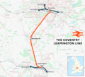 Coventry–Leamington line.png 1,668 × 1,521; 1.72 MB
-
 Coventry–Nuneaton line.png 1,487 × 1,832; 1.96 MB
-
 Leamington–Stratford line.png 2,175 × 1,925; 2.11 MB
-
 London Midland Express.svg 459 × 255; 13 KB
-
 Mcrmap.jpg 400 × 886; 31 KB
-
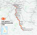
 North Warwickshire Line.png 1,169 × 1,654; 76 KB
-
 North Warwickshire line.png 1,184 × 1,130; 1.34 MB
-
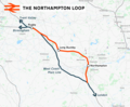 Northampton loop.png 1,648 × 1,360; 1.32 MB
-
 NorthWarwickshireLine.jpg 1,423 × 1,815; 412 KB
-
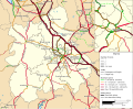 Rail transport infrastructure map - UK - West Midlands.svg 1,059 × 869; 5.49 MB
-
 Railways of Rugby 1950-2000.png 1,600 × 2,406; 227 KB
-
 Railways of Rugby 1950.png 1,600 × 1,246; 166 KB
-
 Railways of Rugby 2019.png 1,600 × 1,130; 87 KB
-
 Rugby Station Diagram 1.png 1,550 × 912; 92 KB
-
 Rugby Station Diagram 2.png 1,564 × 932; 73 KB
-
 Rugby-Stafford rail routes.png 1,755 × 2,482; 201 KB
-
 Rugby–Birmingham–Stafford line.png 2,022 × 1,730; 3.15 MB
-
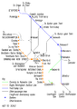
 S&MJA.png 1,547 × 575; 79 KB
-
 S&MT map.jpg 500 × 776; 211 KB
-
 Snow Hill Lines.svg 512 × 419; 1.03 MB
-
 SnowHillLines.png 1,700 × 1,200; 285 KB
-
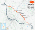 Trent Valley line.png 2,022 × 1,730; 3.15 MB
-
 West Midlands and CrossCountry Network Map.svg 1,400 × 1,120; 262 KB
-
 West Midlands Trains route map 2018 01.png 1,000 × 1,057; 408 KB


.svg)


