Category:Raise, Cumbria
Media in category "Raise, Cumbria"
The following 27 files are in this category, out of 27 total.
-
 Cairn on Raise - geograph.org.uk - 1098169.jpg 640 × 480; 55 KB
-
 Cairn on Raise - geograph.org.uk - 4345271.jpg 4,608 × 3,456; 3.65 MB
-
 Descending Raise - geograph.org.uk - 1098987.jpg 480 × 640; 96 KB
-
 Descending Raise - geograph.org.uk - 4345300.jpg 4,608 × 3,456; 3.69 MB
-

-
 Looking towards Raise summit - geograph.org.uk - 3827759.jpg 1,024 × 768; 348 KB
-
 Looking towards Sticks Pass - geograph.org.uk - 1098684.jpg 640 × 480; 60 KB
-
 On Raise - geograph.org.uk - 1098676.jpg 640 × 480; 68 KB
-
 On Raise - geograph.org.uk - 2231339.jpg 2,560 × 1,920; 1.58 MB
-
 On Raise - geograph.org.uk - 2921031.jpg 2,560 × 1,920; 2.12 MB
-
 On Raise - geograph.org.uk - 649038.jpg 640 × 480; 40 KB
-
 On Raven Crag - geograph.org.uk - 1285519.jpg 640 × 480; 88 KB
-
 Path descending from Raise - geograph.org.uk - 5432909.jpg 6,000 × 4,000; 5.11 MB
-
 Path on Raise - geograph.org.uk - 1098158.jpg 640 × 480; 71 KB
-
 Path to Raise from Sticks Pass - geograph.org.uk - 5432899.jpg 6,000 × 4,000; 5.81 MB
-
 Raise - geograph.org.uk - 2840880.jpg 640 × 480; 93 KB
-
 Raise from White Side - geograph.org.uk - 1074476.jpg 640 × 480; 79 KB
-
 Raise in the Lake District (geograph 5648109).jpg 1,024 × 646; 645 KB
-
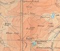 Raise Map.jpg 655 × 564; 67 KB
-
 Southern side of Raise - geograph.org.uk - 2840879.jpg 640 × 480; 84 KB
-
 SW ridge of Raise - geograph.org.uk - 6124146.jpg 1,024 × 768; 232 KB
-
 The slopes of Raise - geograph.org.uk - 5351573.jpg 2,592 × 1,944; 1.55 MB
-
 The summit of Raise - geograph.org.uk - 3827756.jpg 1,024 × 768; 205 KB
-
 The summit of Raise - geograph.org.uk - 5432912.jpg 6,000 × 4,000; 4.89 MB
-
 View North West from the Summit - geograph.org.uk - 1102828.jpg 640 × 427; 66 KB
-
 View West from Raise Summit - geograph.org.uk - 1101135.jpg 640 × 427; 69 KB
-
 West Flank of Raise - geograph.org.uk - 1098087.jpg 640 × 480; 81 KB


.jpg)


