Category:Rankin Hall, Ullet Road
| Object location | | View all coordinates using: OpenStreetMap |
|---|
building in Liverpool, Merseyside, England, UK  | |||||
| Upload media | |||||
| Instance of | |||||
|---|---|---|---|---|---|
| Location | Liverpool, Merseyside, North West England, England | ||||
| Street address |
| ||||
| Heritage designation |
| ||||
 | |||||
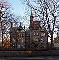
This 1870s mansion is at 44 Ullet Road. and is also not to be confused with the student hall of residence of the same name in Carnatic Road. During the second world war it was the original Rankin Hall, a women's hall of residence.
Media in category "Rankin Hall, Ullet Road"
The following 3 files are in this category, out of 3 total.
-
 Rankin Hall 1.jpg 3,992 × 3,448; 6.99 MB
-
 Rankin Hall 2.jpg 2,480 × 4,272; 4.24 MB
-
 Rankin Hall, Ullet Road 2017.jpg 3,431 × 3,515; 8.13 MB

