Category:Ranworth
English: Ranworth is a village in Norfolk in The Broads, adjacent to Malthouse Broad and Ranworth Broad.
village in United Kingdom  | |||||
| Upload media | |||||
| Instance of | |||||
|---|---|---|---|---|---|
| Location | Woodbastwick, Broadland, Norfolk, East of England, England | ||||
 | |||||
Subcategories
This category has the following 5 subcategories, out of 5 total.
Media in category "Ranworth"
The following 59 files are in this category, out of 59 total.
-
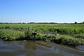 Bank erosion, River Bure - geograph.org.uk - 690478.jpg 640 × 427; 215 KB
-
 Birdwatching Lake - Cockshoot Broad - geograph.org.uk - 400791.jpg 518 × 249; 65 KB
-
-
 From one church to another - geograph.org.uk - 567862.jpg 640 × 480; 93 KB
-
 Gezicht op Barton Broad Dyke on Barton Broad (titel op object), RP-F-2001-7-1162-59.jpg 6,198 × 4,122; 3.16 MB
-
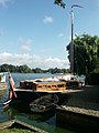
 Hunter's Fleet on the River Bure - geograph.org.uk - 259725.jpg 640 × 481; 169 KB
-
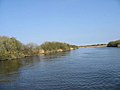 Looking E along the River Bure - geograph.org.uk - 402625.jpg 640 × 480; 32 KB
-
 Mississippi River Boat, Horning - geograph.org.uk - 24689.jpg 640 × 480; 79 KB
-
 Moorings at South Walsham Broad - geograph.org.uk - 232275.jpg 640 × 480; 262 KB
-
 Moorings, Fleet Dike, South Walsham - geograph.org.uk - 232280.jpg 640 × 480; 221 KB
-
 Moorings, Fleet Dike, South Walsham - geograph.org.uk - 232285.jpg 640 × 480; 205 KB
-
-
 Priory Road meets Panxworth Church Road - geograph.org.uk - 567852.jpg 640 × 480; 105 KB
-
 Ranworth - geograph.org.uk - 5670045.jpg 1,000 × 665; 683 KB
-
 Ranworth - geograph.org.uk - 5670050.jpg 1,000 × 665; 764 KB
-
 Ranworth 079.JPG 2,560 × 1,920; 438 KB
-
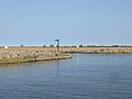
 Ranworth Dam - geograph.org.uk - 3724536.jpg 640 × 480; 61 KB
-
 Ranworth Dam - geograph.org.uk - 5460025.jpg 1,024 × 683; 162 KB
-
 Ranworth Dam from the River Bure - geograph.org.uk - 240106.jpg 640 × 480; 155 KB
-
 Ranworth Marina - geograph.org.uk - 2681969.jpg 800 × 600; 210 KB
-
 Ranworth Moorings - geograph.org.uk - 5660193.jpg 2,399 × 1,599; 468 KB
-
 Ranworth Moorings - geograph.org.uk - 5676032.jpg 3,297 × 2,200; 1.11 MB
-
 Ranworth Moorings off Farm Lane - geograph.org.uk - 5480874.jpg 1,600 × 1,200; 371 KB
-
 Ranworth Old Hall - porch Geograph-2127478-by-Gareth-Hughes.jpg 657 × 1,024; 188 KB
-

-
 Ranworth Village Hall - geograph.org.uk - 566319.jpg 640 × 480; 86 KB
-
 Ranworth village sign.JPG 1,856 × 1,392; 769 KB
-
 River Bure from Ranworth Church - geograph.org.uk - 2391971.jpg 800 × 531; 105 KB
-
 Thatched Cottages, Ranworth - geograph.org.uk - 155560.jpg 640 × 480; 141 KB
-
 The Maltsters - geograph.org.uk - 303098.jpg 640 × 465; 130 KB
-
 The Maltsters in Ranworth - geograph.org.uk - 4382029.jpg 640 × 480; 349 KB
-
 The Maltsters in Ranworth - geograph.org.uk - 4382031.jpg 640 × 506; 346 KB
-
 The Maltsters in Ranworth - geograph.org.uk - 4382033.jpg 640 × 574; 319 KB
-
 The Maltsters in Ranworth - geograph.org.uk - 4382043.jpg 640 × 480; 445 KB
-
 The Maltsters PH, Ranworth - geograph.org.uk - 1141037.jpg 640 × 480; 100 KB
-
 The Maltsters Public House, Ranworth - geograph.org.uk - 6314098.jpg 5,456 × 3,632; 1.02 MB
-
 The Maltsters Public House, Ranworth - geograph.org.uk - 6314099.jpg 2,543 × 3,677; 611 KB
-
 The Maltsters Public House, Ranworth - geograph.org.uk - 6314360.jpg 5,456 × 3,632; 1.65 MB
-
 The Maltsters, Ranworth - geograph.org.uk - 1563110.jpg 640 × 480; 124 KB
-
 The Old House, Ranworth - geograph.org.uk - 5460044.jpg 1,024 × 683; 295 KB
-

-
 View from Ranworth Church Tower - geograph.org.uk - 2391920.jpg 800 × 531; 125 KB
-
 Village sign, Ranworth - geograph.org.uk - 1563104.jpg 640 × 476; 195 KB
-
 Yacht on River Bure near Ranworth - geograph.org.uk - 2430291.jpg 1,600 × 1,200; 450 KB
-
 Bridleway to Leist's Farm - geograph.org.uk - 303072.jpg 640 × 480; 160 KB
-

-
 Fee paying moorings on Malthouse Broad - geograph.org.uk - 400112.jpg 640 × 480; 147 KB
-
 Fields near Leist's Farm - geograph.org.uk - 303092.jpg 640 × 480; 155 KB
-
 Footpath to NWT visitor centre only - geograph.org.uk - 566321.jpg 480 × 640; 111 KB
-
 Grassy track heads towards Draining Pump - geograph.org.uk - 566250.jpg 480 × 640; 132 KB
-
 Heading towards "The Boxes" - geograph.org.uk - 567855.jpg 640 × 480; 99 KB
-

-
 Looking inland from South Walsham marshes - geograph.org.uk - 566335.jpg 640 × 430; 115 KB
-

-
 Ploughed field near Woodbastwick Road - geograph.org.uk - 566303.jpg 640 × 480; 87 KB
-

-
 Private road to Old Hall - geograph.org.uk - 566306.jpg 480 × 640; 100 KB
-
 Track connecting with Panxworth Road - geograph.org.uk - 566298.jpg 640 × 480; 72 KB
-
 View SW along Ranworth Dam - geograph.org.uk - 400130.jpg 640 × 480; 38 KB


,_RP-F-2001-7-1162-59.jpg)


