Category:Regions of Texas
States of the United States: Alaska · Arizona · Arkansas · California · Connecticut · Florida · Idaho · Kentucky · Louisiana · Maryland · Massachusetts · Montana · Nevada · New Jersey · New Mexico · New York · North Carolina · Ohio · Oklahoma · Oregon · Pennsylvania · South Dakota · Tennessee · Texas · Utah · Virginia · Washington · Wisconsin · Wyoming
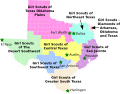
English: The Regions of Texas.
Español: Regiones de Texas
Wikimedia category | |||||
| Upload media | |||||
| Instance of | |||||
|---|---|---|---|---|---|
| Category combines topics | |||||
| Texas | |||||
state of the United States of America  someja da satełite in zuño      | |||||
| Pronunciation audio | |||||
| Instance of | |||||
| Part of | |||||
| Named after |
| ||||
| Location |
| ||||
| Located in or next to body of water |
| ||||
| Capital | |||||
| Legislative body |
| ||||
| Executive body | |||||
| Highest judicial authority |
| ||||
| Anthem |
| ||||
| Head of government |
| ||||
| Inception |
| ||||
| Highest point | |||||
| Population |
| ||||
| Area |
| ||||
| Elevation above sea level |
| ||||
| Replaces | |||||
| Different from | |||||
| Maximum temperature record |
| ||||
| Minimum temperature record |
| ||||
| official website | |||||
 | |||||
Subcategories
This category has the following 19 subcategories, out of 19 total.
.
A
B
C
E
L
P
R
S
T
W
Media in category "Regions of Texas"
The following 54 files are in this category, out of 54 total.
-
 BVCOG.png 300 × 278; 27 KB
-
 CAPCOG.png 300 × 278; 27 KB
-
 CBCOG.png 300 × 278; 27 KB
-
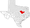
 Central Texas map.PNG 300 × 284; 12 KB
-
 CentralTexas.svg 512 × 512; 305 KB
-
 CTCOG.png 300 × 278; 28 KB
-
 CVCOG.png 300 × 278; 27 KB
-
 Deep East Texas map.png 447 × 437; 15 KB
-
 DETCOG.png 300 × 278; 27 KB
-
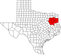
 East Texas map.PNG 447 × 437; 18 KB
-
 East Texas – Landschaftliche Gliederung.jpg 2,876 × 4,740; 3.07 MB
-
 East Texas – Regional Councils of Government alternate.jpg 3,626 × 4,964; 2.98 MB
-
 East Texas – Regional Councils of Government.jpg 2,876 × 4,937; 3.79 MB
-
 EastTexas.svg 512 × 512; 305 KB
-
 ES-Texas Population Density.png 624 × 475; 93 KB
-
 ETCOG.png 300 × 278; 27 KB
-
 Galveston Bay.jpg 3,264 × 2,448; 1.46 MB
-
 GCRPC.png 300 × 278; 27 KB
-
 H-GAC.png 300 × 278; 27 KB
-
 HOTCOG.png 300 × 278; 28 KB
-
 Houston Galveston area towns roadmap.gif 399 × 342; 35 KB
-
 LlanoEstacadoShadedRelief.jpg 302 × 365; 32 KB
-
 LRGVDC.png 300 × 278; 27 KB
-

-
 MRGDC.png 300 × 278; 27 KB
-
 NCTCOG.png 300 × 278; 28 KB
-
 NORTEX.png 300 × 278; 27 KB
-
 North East Texas.png 300 × 278; 18 KB
-
 North Texas map.png 447 × 437; 15 KB
-
 NorthTexas.svg 512 × 512; 305 KB
-
 PBRPC.png 300 × 278; 28 KB
-
 Regions of Texas.PNG 302 × 284; 16 KB
-
 Regions of Texas.svg 512 × 512; 307 KB
-
 RGCOG.png 300 × 278; 27 KB
-
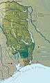
 Rio grande valley overview.jpg 3,594 × 1,858; 1.13 MB
-
 SeaWorldTexas1.jpg 2,112 × 2,816; 1.07 MB
-
 SETRPC.png 300 × 278; 28 KB
-
 SouthTexas.svg 512 × 512; 305 KB
-
 SPAG.png 300 × 278; 27 KB
-
 STDC.png 300 × 278; 27 KB
-
 Texas Hill Country Map.png 829 × 758; 48 KB
-
 Texas timezones.jpg 1,200 × 1,121; 580 KB
-
 Texas-gsusa.svg 15,188 × 11,855; 672 KB
-
 TexasPanhandle.svg 512 × 512; 305 KB
-
 TexasRegions.svg 512 × 512; 307 KB
-
 TexasSouthPlains.svg 512 × 512; 305 KB
-
 TexasValley.svg 512 × 512; 305 KB
-
 Map of texoma area.jpg 913 × 435; 134 KB
-
 TEXOMA.png 300 × 278; 28 KB
-
 TransPecosTexas.svg 512 × 512; 305 KB
-
 TXMap-RGV-Shaded.png 300 × 284; 22 KB
-
 WCTCOG.png 300 × 278; 28 KB
-
 West Texas Scenery.JPG 2,592 × 1,944; 657 KB
-
 WestTexas.svg 512 × 512; 305 KB


