Category:Ridderstraat 14, Hattem
| Object location | | View all coordinates using: OpenStreetMap |
|---|
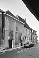
building in Hattem, Netherlands  | |||||
| Upload media | |||||
| Instance of | |||||
|---|---|---|---|---|---|
| Location | Hattem, Gelderland, Netherlands | ||||
| Street address |
| ||||
| Located on street |
| ||||
| Heritage designation |
| ||||
 | |||||
|
This is a category about rijksmonument number 20985
|
| Address |
|
Media in category "Ridderstraat 14, Hattem"
The following 5 files are in this category, out of 5 total.
-
 Hattem20985.jpg 4,288 × 2,848; 4.81 MB
-
 Voordeur - Hattem - 20103389 - RCE.jpg 1,197 × 1,200; 309 KB
-
 Voorgevel - Hattem - 20103388 - RCE.jpg 1,190 × 1,200; 263 KB
-
 Voorgevels - Hattem - 20103391 - RCE.jpg 807 × 1,200; 167 KB
-
 Voorgevels - Hattem - 20103393 - RCE.jpg 819 × 1,200; 175 KB


