Category:Rijksstraatweg 119, Loenen aan de Vecht
| Object location | | View all coordinates using: OpenStreetMap |
|---|
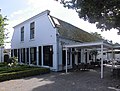
farmhouse in Stichtse Vecht, Netherlands  | |||||
| Upload media | |||||
| Instance of | |||||
|---|---|---|---|---|---|
| Location | Loenen aan de Vecht, Stichtse Vecht, Utrecht, Netherlands | ||||
| Street address |
| ||||
| Located on street |
| ||||
| Heritage designation |
| ||||
 | |||||
|
This is a category about rijksmonument number 26084
|
| Address |
|
Media in category "Rijksstraatweg 119, Loenen aan de Vecht"
The following 3 files are in this category, out of 3 total.
-
 Houten bank rond eik - Loenen aan de Vecht - 20141822 - RCE.jpg 1,198 × 1,200; 415 KB
-
 Loenen aan de Vecht - Rijksstraatweg 119 RM26084.JPG 4,461 × 3,396; 3.25 MB
-
 Voordeur van voormalige boerderij - Loenen aan de Vecht - 20141823 - RCE.jpg 1,200 × 1,197; 340 KB

