Category:Rijksstraatweg 155, Baambrugge
| Object location | | View all coordinates using: OpenStreetMap |
|---|
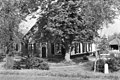
farmhouse in De Ronde Venen, Netherlands  | |||||
| Upload media | |||||
| Instance of | |||||
|---|---|---|---|---|---|
| Location | Baambrugge, Utrecht, Netherlands | ||||
| Street address |
| ||||
| Located on street |
| ||||
| Heritage designation |
| ||||
 | |||||
Nederlands: Petronellahoeve
|
This is a category about rijksmonument number 7029
|
| Address |
|
Media in category "Rijksstraatweg 155, Baambrugge"
The following 5 files are in this category, out of 5 total.
-
 Overzicht - Baambrugge - 20004333 - RCE.jpg 1,200 × 798; 314 KB
-
 Rijksmonument 7029 Rijksstraatweg 155 Baambrugge.JPG 4,032 × 3,024; 6.08 MB
-
 Voor en zijgevel - Baambrugge - 20026728 - RCE.jpg 1,195 × 1,200; 526 KB
-
 Voor- en zijgevel nr. FJ1 2 - Baambrugge - 20466861 - RCE.jpg 1,200 × 900; 224 KB
-
 Voorgevel - Baambrugge - 20026727 - RCE.jpg 1,186 × 1,200; 480 KB


