Category:Ripe, East Sussex
village and former civil parish in East Sussex, England .jpg) | |||||
| Upload media | |||||
| Instance of |
| ||||
|---|---|---|---|---|---|
| Location | Chalvington with Ripe, Wealden, East Sussex, South East England, England | ||||
 | |||||
Subcategories
This category has the following 8 subcategories, out of 8 total.
E
- Eckington House (2 F)
- Eckington Manor, East Sussex (3 F)
L
- Lamb Inn, Ripe, East Sussex (8 F)
O
- The Old Cottage, Ripe (6 F)
P
- Pepperham (4 F)
R
- Ripe War Memorial (2 F)
Media in category "Ripe, East Sussex"
The following 30 files are in this category, out of 30 total.
-
 Bridge over stream, Darp Lane, Ripe, East Sussex - geograph.org.uk - 2114543.jpg 1,600 × 1,200; 694 KB
-
-
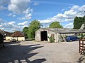 Church Farm, Ripe - geograph.org.uk - 1889497.jpg 1,024 × 768; 227 KB
-
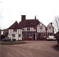
 Church Lane and Lamb Inn, Ripe - geograph.org.uk - 1031536.jpg 640 × 495; 98 KB
-
 Church Lane Ripe - geograph.org.uk - 2915082.jpg 4,000 × 3,000; 3.16 MB
-
 Crossroads near Ripe - geograph.org.uk - 1889600.jpg 1,024 × 768; 272 KB
-
 Entrance to Court Hall Farm, Ripe - geograph.org.uk - 1031266.jpg 640 × 480; 154 KB
-
 Entrance to Hall Court Farm, Ripe, East Sussex - geograph.org.uk - 1928654.jpg 1,600 × 1,200; 492 KB
-
 Firle Road south out of Ripe - geograph.org.uk - 2915189.jpg 4,000 × 3,000; 3.18 MB
-
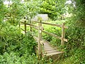 Footbridge, Ripe - geograph.org.uk - 2438894.jpg 2,560 × 1,920; 2.36 MB
-
 Footpath at Ripe - geograph.org.uk - 2438906.jpg 2,560 × 1,920; 1.85 MB
-
 Footpath near Ripe - geograph.org.uk - 1031288.jpg 480 × 640; 163 KB
-
 Former National School, Ripe - geograph.org.uk - 1031570.jpg 640 × 432; 159 KB
-
 George Hayton Baker (7723695402).jpg 1,552 × 2,592; 741 KB
-
 Horse riding near Ripe, East Sussex - geograph.org.uk - 2480489.jpg 1,600 × 1,089; 299 KB
-
 Mark Cross Lane, Ripe - geograph.org.uk - 2597871.jpg 640 × 428; 137 KB
-
 Near Ripe - geograph.org.uk - 1031283.jpg 640 × 533; 77 KB
-
 Obelisk in the grounds of The Old Rectory Ripe - geograph.org.uk - 2915145.jpg 4,000 × 3,000; 3.34 MB
-
 Ripe Lane SW to Ripe - geograph.org.uk - 2918323.jpg 4,000 × 3,000; 3.54 MB
-
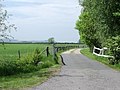
 Ripe Lane, Ripe - geograph.org.uk - 1651936.jpg 640 × 480; 67 KB
-
 Signpost in Ripe village centre, East Sussex - geograph.org.uk - 2111682.jpg 1,200 × 1,600; 496 KB
-
 The hub of Ripe village - geograph.org.uk - 2916781.jpg 4,000 × 3,000; 3.29 MB
-
 The Manor House, Ripe.jpg 4,435 × 2,997; 3.24 MB
-
 The Street Ripe - geograph.org.uk - 2916729.jpg 4,000 × 3,000; 3.52 MB
-
 The Street, Ripe - geograph.org.uk - 1651923.jpg 640 × 480; 69 KB
-
 The White Cottage, Ripe.jpg 3,934 × 3,431; 2.84 MB
-
 Three way junction in Ripe - geograph.org.uk - 2916712.jpg 4,000 × 3,000; 3.61 MB
-
 Village Square, Ripe - geograph.org.uk - 62623.jpg 640 × 479; 139 KB
-
 White Cottage, Ripe - geograph.org.uk - 2438884.jpg 2,560 × 1,920; 2.26 MB
-
 Willow tree on the corner of Church Lane Ripe - geograph.org.uk - 2915073.jpg 4,000 × 3,000; 3.46 MB


.jpg)


