Category:Risca West
community in Caerphilly County Borough, Wales, UK   | |||||
| Upload media | |||||
| Instance of | |||||
|---|---|---|---|---|---|
| Location | Caerphilly County Borough, Wales | ||||
| Population |
| ||||
| Area |
| ||||
 | |||||
Subcategories
This category has the following 6 subcategories, out of 6 total.
D
P
R
- St Mary's Church, Risca (3 F)
T
- Tredegar Grounds (6 F)
- Tredegar Street, Risca (30 F)
- Twmbarlwm (31 F)
Media in category "Risca West"
The following 200 files are in this category, out of 436 total.
(previous page) (next page)-

-
 2024 Wales Caerphilly Community Risca West map.svg 512 × 725; 345 KB
-
 A bend in the A467, Risca - geograph.org.uk - 3409040.jpg 640 × 498; 85 KB
-
 A straight square in Risca - geograph.org.uk - 5230874.jpg 800 × 749; 112 KB
-
 A467 approaching roundabout with B4591, Pontymister - geograph.org.uk - 5578090.jpg 5,179 × 3,451; 4.86 MB
-
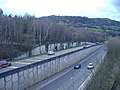
 A467 between Risca and Pontymister - geograph.org.uk - 3409045.jpg 640 × 480; 70 KB
-
 A467, near Risca - geograph.org.uk - 351921.jpg 640 × 480; 70 KB
-

-
 Across a river footbridge, Risca - geograph.org.uk - 5250402.jpg 800 × 600; 128 KB
-

-
 Aldi, Pontymister - geograph.org.uk - 2272019.jpg 640 × 480; 53 KB
-

-
 Alphavet, Risca - geograph.org.uk - 5230892.jpg 793 × 800; 120 KB
-
 American Villas, Church Road, Risca - geograph.org.uk - 2238577.jpg 640 × 480; 82 KB
-
 Approaching Green Meadow Bridge from the west - geograph.org.uk - 5589926.jpg 5,179 × 3,451; 6.03 MB
-
 Autocentres, Risca - geograph.org.uk - 5231879.jpg 800 × 615; 84 KB
-
 Band Box, Commercial Street, Pontymister - geograph.org.uk - 5817260.jpg 800 × 720; 129 KB
-

-

-

-
 Bend in the Ebbw River, Risca - geograph.org.uk - 5250412.jpg 800 × 567; 119 KB
-
 Bengal Cymru, Risca House, Pontymister - geograph.org.uk - 5816048.jpg 800 × 595; 101 KB
-
 Best Choice Heating, Risca - geograph.org.uk - 5250325.jpg 800 × 767; 116 KB
-
 Bethany Baptist Church, Risca - geograph.org.uk - 2016388.jpg 640 × 480; 81 KB
-
 Bhajees in Risca - geograph.org.uk - 5817146.jpg 800 × 740; 139 KB
-

-
 Blackvein Road semis, Crosskeys - geograph.org.uk - 5785111.jpg 800 × 591; 125 KB
-
 Bladez and Blusher, Pontymister - geograph.org.uk - 3407416.jpg 640 × 551; 88 KB
-
 Boer War Memorial Tree, Risca - geograph.org.uk - 5249802.jpg 483 × 800; 132 KB
-
 Braithwaite in Pontymister - geograph.org.uk - 5758628.jpg 800 × 682; 188 KB
-

-
 Brookland Road, Risca - geograph.org.uk - 1756323.jpg 640 × 520; 68 KB
-

-

-
 Bus stop and shelter on a Pontymister corner - geograph.org.uk - 5966877.jpg 985 × 1,024; 226 KB
-

-

-
 Cafe Cuckoo, Risca - geograph.org.uk - 5231900.jpg 672 × 800; 102 KB
-
 Canal bridge near Darran Road, Risca - geograph.org.uk - 3815241.jpg 800 × 592; 196 KB
-
 Canal entrance from Darran Road, Risca - geograph.org.uk - 3813647.jpg 800 × 743; 263 KB
-

-
 Canalside houses, Temperance Hill, Risca - geograph.org.uk - 2238594.jpg 640 × 583; 102 KB
-

-
 Children's play area in Pontymister - geograph.org.uk - 5968689.jpg 1,024 × 681; 203 KB
-
 Christabel Photography, Risca - geograph.org.uk - 5817118.jpg 726 × 800; 128 KB
-
 Cleared edge of pond, Dan-y-Graig LNR - geograph.org.uk - 5699950.jpg 5,179 × 3,451; 6.12 MB
-
 Clyde Street, Pontymister - geograph.org.uk - 5816029.jpg 689 × 800; 116 KB
-
 Cobblers Cabin ^ Key Rac, Risca - geograph.org.uk - 5231298.jpg 706 × 800; 97 KB
-
 Colourful mural, Pontymister - geograph.org.uk - 3407102.jpg 640 × 496; 111 KB
-
 Commercial Lane, Pontymister - geograph.org.uk - 5816090.jpg 800 × 677; 125 KB
-

-
 Commercial Street - geograph.org.uk - 2750330.jpg 640 × 453; 50 KB
-
 Commercial Street - geograph.org.uk - 2750339.jpg 640 × 480; 60 KB
-

-
 Coptic Orthodox Church in Risca - geograph.org.uk - 5756187.jpg 800 × 718; 128 KB
-

-
 Coronation Street - geograph.org.uk - 3114099.jpg 640 × 480; 57 KB
-
 Cottage near canal bank - geograph.org.uk - 1953053.jpg 3,648 × 2,736; 2.4 MB
-
 Cromwell Road houses, Risca - geograph.org.uk - 2419712.jpg 640 × 558; 79 KB
-
 Crumlin Arm canal sign, Risca - geograph.org.uk - 2238595.jpg 526 × 640; 114 KB
-
 Cwm-y-nant farmhouse, Risca - geograph.org.uk - 2252148.jpg 640 × 455; 84 KB
-
 Cwrt Yr Ysgol, Risca - geograph.org.uk - 5249834.jpg 800 × 539; 115 KB
-

-
 Dan-y-Graig Nature Reserve, Risca - geograph.org.uk - 4654205.jpg 5,078 × 3,451; 5.57 MB
-
 Dan-y-Graig Nature Reserve, Risca, November - geograph.org.uk - 4737450.jpg 5,110 × 3,451; 5.33 MB
-
 Danygraig Road houses, Risca (geograph 2715155).jpg 640 × 526; 84 KB
-
 Danygraig Road, Risca (geograph 3408969).jpg 640 × 478; 80 KB
-
 Darran Road above Risca - geograph.org.uk - 5592248.jpg 5,179 × 3,451; 4.6 MB
-
 Darran Road bus stop, Risca - geograph.org.uk - 3813711.jpg 800 × 600; 243 KB
-
 Darran Road houses, Risca - geograph.org.uk - 3813589.jpg 800 × 585; 165 KB
-
 Darran Road to Hansons Lodge - geograph.org.uk - 5592271.jpg 5,184 × 3,456; 7.01 MB
-

-

-

-

-

-

-
 Direction signs in Pontymister - geograph.org.uk - 5758669.jpg 724 × 800; 150 KB
-

-
 Doodle Dogz Grooming, Risca - geograph.org.uk - 5231871.jpg 722 × 800; 120 KB
-
 Down Darran Road, Risca - geograph.org.uk - 3811628.jpg 800 × 587; 200 KB
-
 Downstream along the Ebbw River, Risca - geograph.org.uk - 5250406.jpg 800 × 552; 114 KB
-

-

-

-
 Ebbw footbridge, Pontymister - geograph.org.uk - 2272088.jpg 640 × 432; 73 KB
-

-
 Ebbw River footbridge, Risca - geograph.org.uk - 5250393.jpg 800 × 600; 151 KB
-
 Ebbw River upstream, Pontymister - geograph.org.uk - 2272035.jpg 640 × 480; 67 KB
-
 Ebbw River, Risca - geograph.org.uk - 5232583.jpg 800 × 600; 139 KB
-

-
 Ebbw Street, Risca (geograph 2715192).jpg 640 × 576; 90 KB
-
 Ebbw Street, Risca (geograph 3408801).jpg 640 × 492; 91 KB
-
 Ebbw Valley Railway, Risca - geograph.org.uk - 5580184.jpg 5,184 × 3,456; 7.55 MB
-
 Ebenezers Emporium, Risca - geograph.org.uk - 2704736.jpg 640 × 425; 67 KB
-

-
 Electricity substation, St Mary Street, Risca - geograph.org.uk - 5937547.jpg 1,024 × 970; 237 KB
-
 EMD (Eco Mini Diggers) in Risca - geograph.org.uk - 3813542.jpg 800 × 632; 246 KB
-

-

-
 Esso filling station and shop, Risca - geograph.org.uk - 3811496.jpg 800 × 500; 117 KB
-

-
 Exchange Road houses, Risca - geograph.org.uk - 5258197.jpg 800 × 496; 84 KB
-
 Exchange Road houses, Risca - geograph.org.uk - 5258212.jpg 800 × 531; 106 KB
-
 Exchange Stores and post office, Risca - geograph.org.uk - 5258186.jpg 800 × 656; 100 KB
-
 Fenced-off building site, Mill Street, Pontymister - geograph.org.uk - 5983352.jpg 3,494 × 1,849; 1.01 MB
-
 Fernlea allotments, Risca - geograph.org.uk - 2252164.jpg 640 × 480; 76 KB
-
 Fernlea, Risca - geograph.org.uk - 2238610.jpg 640 × 444; 58 KB
-

-

-
 Fitwell, Pontymister - geograph.org.uk - 2704974.jpg 629 × 640; 86 KB
-
 Footbridge across the A467 - geograph.org.uk - 2743104.jpg 1,024 × 763; 105 KB
-
 Footbridge across the A467 - geograph.org.uk - 351919.jpg 640 × 480; 111 KB
-
 Footbridge across the railway near Risca - geograph.org.uk - 3626065.jpg 4,000 × 3,000; 3.92 MB
-
 Footbridge across the railway near Risca - geograph.org.uk - 3626111.jpg 3,909 × 2,933; 4.81 MB
-
 Footbridge over A467, Pontymister - geograph.org.uk - 5578104.jpg 5,179 × 3,451; 4.99 MB
-
 Footpath in Dan-y-Graig Nature Reserve, Risca - geograph.org.uk - 4737380.jpg 5,104 × 3,398; 5.09 MB
-
 Footpath, Dan-y-Graig Nature Reserve - geograph.org.uk - 4737344.jpg 5,184 × 3,456; 2.9 MB
-
 Footpath, Raven Walk, from canal towpath - geograph.org.uk - 5589878.jpg 5,179 × 3,451; 5.33 MB
-
 Former Flower Boutique, Risca - geograph.org.uk - 2704754.jpg 640 × 437; 94 KB
-

-

-

-

-
 Former Ty Darran care home, Risca - geograph.org.uk - 2419733.jpg 640 × 584; 88 KB
-

-
 Gelli Avenue railway bridge, Risca - geograph.org.uk - 1756455.jpg 640 × 480; 78 KB
-

-

-

-
 Graig View houses, Risca (geograph 5232894).jpg 800 × 709; 109 KB
-
 Grass bank, Dan-y-Graig Nature Reserve, Risca - geograph.org.uk - 4737467.jpg 5,142 × 3,451; 7.25 MB
-

-

-
 Green Meadow Bridge 17 Monmouthshire & Brecon Canal.jpg 5,179 × 3,451; 6.34 MB
-
 Green Meadow Bridge over Monmouthshire ^ Brecon Canal - geograph.org.uk - 5579821.jpg 5,179 × 3,451; 6.59 MB
-
 Grove Road houses, Risca - geograph.org.uk - 5258213.jpg 800 × 661; 140 KB
-
 Grove Road towards Crescent Road, Risca - geograph.org.uk - 5258201.jpg 800 × 643; 108 KB
-

-
 Heolas Farm, Upper Ochrwyth - geograph.org.uk - 5578074.jpg 5,179 × 3,451; 4.71 MB
-
 Heollas farm, Upper Ochrwyth - geograph.org.uk - 351923.jpg 480 × 640; 104 KB
-
 Highfield House, Risca - geograph.org.uk - 2238622.jpg 640 × 394; 61 KB
-
 Hillside trenches, Cwm Carn - geograph.org.uk - 5333931.jpg 5,179 × 3,451; 5.13 MB
-
 House Clearance Centre, Risca - geograph.org.uk - 2704745.jpg 640 × 480; 82 KB
-

-

-

-
 Information board outside Dan-y-graig Church, Risca - geograph.org.uk - 5935859.jpg 2,155 × 1,984; 772 KB
-

-
 Isaf Road, Pontymister - geograph.org.uk - 5758468.jpg 692 × 800; 103 KB
-
 Islwyn Lily and Canal Boat Tearoom at Whysom's Wharf - geograph.org.uk - 5579334.jpg 5,179 × 3,451; 6.19 MB
-
 Islwyn Lily at Whysom's Wharf, Monmouthshire ^ Brecon Canal - geograph.org.uk - 5579017.jpg 5,179 × 3,451; 5.02 MB
-

-

-

-

-
 JV Graphics, Risca - geograph.org.uk - 5250329.jpg 800 × 777; 129 KB
-

-
 King George V pillarbox on a Pontymister corner - geograph.org.uk - 5968658.jpg 952 × 1,024; 346 KB
-

-
 Kissing gate near Monmouthshire ^ Brecon Canal - geograph.org.uk - 5579830.jpg 5,179 × 3,451; 4.96 MB
-
 Kissing gate to path from track below Mynydd Machen - geograph.org.uk - 5181522.jpg 5,179 × 3,451; 4.58 MB
-
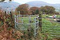
 Kissing gate, Raven Walk, above Risca - geograph.org.uk - 5181178.jpg 5,179 × 3,451; 6.69 MB
-
 Lane to Llan-danglws Farm - geograph.org.uk - 5577272.jpg 5,179 × 3,451; 5.36 MB
-
 Lane-like Darran Road north of Risca - geograph.org.uk - 3815287.jpg 798 × 800; 314 KB
-
 Last bank remaining in Risca - geograph.org.uk - 5756036.jpg 800 × 646; 106 KB
-
 Last leaves of autumn - geograph.org.uk - 1041739.jpg 640 × 480; 182 KB
-
 Late April blossom in Pontymister - geograph.org.uk - 5757181.jpg 800 × 694; 146 KB
-
 Level crossing, Medart Street - geograph.org.uk - 5580105.jpg 5,179 × 3,451; 5.01 MB
-

-
 Lidl Risca on a bank of the Ebbw River - geograph.org.uk - 5817185.jpg 800 × 640; 136 KB
-
 Llanarth Square, Pontymister - geograph.org.uk - 5815988.jpg 947 × 1,128; 230 KB
-
 Llanarth Square, Risca - geograph.org.uk - 5230880.jpg 800 × 747; 98 KB
-
 Lloyds Pharmacy, Risca - geograph.org.uk - 5249681.jpg 800 × 560; 91 KB
-
 Looking back from path to Twmbarlwm - geograph.org.uk - 1923809.jpg 640 × 480; 103 KB
-
 Lucozade advert above Tredegar Street, Risca - geograph.org.uk - 5937535.jpg 1,024 × 972; 204 KB
-
 Lyne Road, Risca - geograph.org.uk - 1756353.jpg 640 × 442; 63 KB
-
 M S Motors, Risca - geograph.org.uk - 5231274.jpg 783 × 800; 128 KB
-
 Madison Gardens, Risca - geograph.org.uk - 2419761.jpg 640 × 480; 81 KB
-
 Madison Gardens, Risca - geograph.org.uk - 5249641.jpg 800 × 752; 168 KB
-
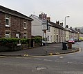
 Malvern Terrace, Pontymister - geograph.org.uk - 2714175.jpg 640 × 584; 80 KB
-
 Malvern Terrace, Pontymister - geograph.org.uk - 5825756.jpg 800 × 714; 137 KB
-

-
 Maple Gardens, Pontymister - geograph.org.uk - 5757192.jpg 800 × 689; 157 KB
-
 Martyn Ashfield Cycles, Risca - geograph.org.uk - 5250323.jpg 800 × 712; 121 KB
-
 Maryland Road, Pontymister - geograph.org.uk - 5815997.jpg 800 × 768; 130 KB
-

-
 Meadow Crescent, Pontymister - geograph.org.uk - 5757321.jpg 800 × 536; 93 KB
-
 Medart Place houses, Crosskeys - geograph.org.uk - 5785082.jpg 800 × 604; 123 KB
-
 Medart Street (2), Risca - geograph.org.uk - 5593769.jpg 5,179 × 3,451; 4.38 MB
-
 Medart Street, Risca - geograph.org.uk - 5580195.jpg 5,179 × 3,451; 4.06 MB
-
 Mill Street Car Park, Pontymister - geograph.org.uk - 5759479.jpg 800 × 506; 100 KB
-
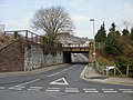
 Mill Street railway bridge, Pontymister - geograph.org.uk - 5758491.jpg 800 × 629; 147 KB
-
 Mill Terrace, Risca - geograph.org.uk - 1749480.jpg 640 × 462; 64 KB
-

-
 Monmouthshire ^ Brecon Canal (Crumlin Arm) near Risca - geograph.org.uk - 3626091.jpg 4,000 × 3,000; 4.66 MB
-
 Monmouthshire ^ Brecon Canal (Crumlin Arm) near Risca - geograph.org.uk - 3626098.jpg 4,000 × 3,000; 4.51 MB
-
 Monmouthshire ^ Brecon Canal alongside Darran Road - geograph.org.uk - 5579002.jpg 5,179 × 3,451; 5.89 MB
-
 Monmouthshire ^ Brecon Canal from Green Meadow Bridge - geograph.org.uk - 5580026.jpg 5,184 × 3,456; 7.72 MB
-
 Monmouthshire ^ Brecon Canal south east of Navigation Road - geograph.org.uk - 5578758.jpg 5,179 × 3,451; 4.15 MB


.jpg)
.jpg)


.jpg)
.jpg)


_in_Risca_-_geograph.org.uk_-_3813542.jpg)


.jpg)


,_Risca_-_geograph.org.uk_-_5593769.jpg)


_near_Risca_-_geograph.org.uk_-_3626091.jpg)
_near_Risca_-_geograph.org.uk_-_3626098.jpg)


