Category:River Cocker, Cumbria
river in Cumbria, United Kingdom  | |||||
| Upload media | |||||
| Instance of | |||||
|---|---|---|---|---|---|
| Location | Cumbria, North West England, England | ||||
| Mouth of the watercourse | |||||
 | |||||
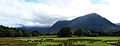
English: The River Cocker is a river in the Lake District in North West England, in the county of Cumbria. Its source is at the head of the Buttermere valley. It flows north through Buttermere and then Crummock Water, through Lorton Vale, to the town of Cockermouth, where it joins the River Derwent. It is roughly 12 miles long. The river takes its name from the Brythonic Celtic word "kukra", meaning crooked. (→River Cocker, Cumbria)
Media in category "River Cocker, Cumbria"
The following 20 files are in this category, out of 20 total.
-
 Comb Beck, Buttermere 1.JPG 3,456 × 4,608; 5.6 MB
-
 Ordnance Survey Sheet NY 12 Lorton Vale, Published 1953.jpg 7,386 × 7,535; 5.52 MB
-
 River Cocker - geograph.org.uk - 1278489.jpg 640 × 427; 60 KB
-
 River Cocker - geograph.org.uk - 461340.jpg 480 × 640; 150 KB
-
 River Cocker - geograph.org.uk - 461341.jpg 640 × 480; 101 KB
-
 River Cocker - geograph.org.uk - 461344.jpg 640 × 480; 156 KB
-
 River Cocker - geograph.org.uk - 461368.jpg 640 × 480; 167 KB
-
 River Cocker - geograph.org.uk - 461369.jpg 640 × 480; 98 KB
-
 River Cocker - geograph.org.uk - 953781.jpg 640 × 480; 92 KB
-
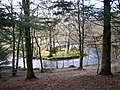 River Meander, Brackenthwaite - geograph.org.uk - 86253.jpg 640 × 480; 162 KB
-
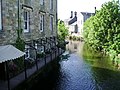
 Rivers meet, Cockermouth - panoramio.jpg 2,048 × 1,536; 499 KB
-
 Sluices at the end of Crummock Water - geograph.org.uk - 1177673.jpg 640 × 425; 52 KB
-
 The Cocker leaves Crummock Water - geograph.org.uk - 880163.jpg 640 × 480; 110 KB
-
 The River Cocker - geograph.org.uk - 1177667.jpg 640 × 425; 91 KB
-
 The River Cocker at Low Lorton - geograph.org.uk - 511358.jpg 640 × 480; 136 KB
-
 The River Cocker at Low Lorton - geograph.org.uk - 511365.jpg 640 × 480; 128 KB
-
 Upstream from Scalehill Bridge - geograph.org.uk - 880155.jpg 640 × 480; 105 KB
-
-
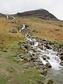
 Warnscale.JPG 4,608 × 3,456; 4.64 MB
-


