Category:River Suir
The River Suir rises in north Tipperary and flows into the Atlantic Ocean near Waterford.
river in Ireland  | |||||
| Upload media | |||||
| Instance of | |||||
|---|---|---|---|---|---|
| Location |
| ||||
| Length |
| ||||
| Mouth of the watercourse | |||||
| Tributary |
| ||||
 | |||||
Subcategories
This category has the following 9 subcategories, out of 9 total.
D
G
- Golden Castle (5 F)
- Granagh Castle (18 F)
H
- Holycross Bridge (8 F)
O
- Old Bridge, Carrick-on-Suir (3 F)
R
- Redmond Bridge, Waterford (3 F)
- River Suir Bridge (15 F)
S
- Sir Thomas' Bridge (4 F)
T
Media in category "River Suir"
The following 92 files are in this category, out of 92 total.
-
 Waterford 1714 (Moll).jpg 1,115 × 870; 241 KB
-
 Adelphi Hotel (6600175993).jpg 2,445 × 1,890; 511 KB
-
 ArdfinnanCastleByDavidMulcahy.jpg 562 × 375; 194 KB
-
 Athassel Priory St. Edmund River Suir 2012 09 05.jpg 3,312 × 2,216; 5.56 MB
-
 Athassel Priory St. Edmund River Suir II 2012 09 05.jpg 3,504 × 2,336; 7.05 MB
-
 Athassel Priory St. Edmund River Suir III 2012 09 05.jpg 3,504 × 2,336; 6.42 MB
-
 Lord William Beresford's funeral.jpg 2,000 × 1,529; 1.46 MB
-
 Boat Slip - geograph.org.uk - 1286114.jpg 591 × 443; 293 KB
-
 Boats on the river Suir, Waterford - geograph.org.uk - 1540699.jpg 640 × 443; 58 KB
-
 Cahir Bridge Cahir 1.jpg 4,500 × 3,322; 7.45 MB
-
 Cahir Bridge Cahir 2.jpg 4,524 × 3,356; 6.23 MB
-
 Cahir Bridge Cahir 3.jpg 4,180 × 3,262; 5.97 MB
-
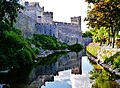
 Cahir Cahir Castle Exterior East Side 1.jpg 4,509 × 3,325; 6.19 MB
-
 Cahir Cahir Castle Exterior East Side 2.jpg 4,494 × 3,314; 7.45 MB
-
 Cahir Cahir Castle Exterior East Side 5.jpg 4,523 × 3,251; 5.97 MB
-
 Cahir Cahir Castle Exterior North Side 1.jpg 4,559 × 3,350; 7.86 MB
-
 Cahir Castle and the River Suir - geograph.org.uk - 264667.jpg 640 × 480; 100 KB
-
 Cahir Castle at the River Suir 2012 09 05.jpg 3,427 × 2,285; 5.71 MB
-
 Cahir Church of St. Paul and River Suir as seen from Bridge Street 2012 09 05.jpg 3,443 × 2,295; 6.35 MB
-
 Cahir River Suir 1.jpg 4,550 × 3,392; 7.32 MB
-
 Cahir River Suir 2.jpg 4,592 × 3,276; 8.82 MB
-
 Cahir River Suir 3.jpg 4,524 × 3,356; 6.81 MB
-
 Cahir River Suir 4.jpg 4,484 × 3,298; 7.79 MB
-
 Castle ruins - geograph.org.uk - 1368047.jpg 640 × 480; 93 KB
-
 Castles of Munster, Ardfinnan, Tipperary - geograph.org.uk - 1393364.jpg 1,024 × 683; 975 KB
-
 Cheekpoint harbour on river Suir County Waterford 2010.jpg 2,288 × 1,712; 767 KB
-
-
 Country House beside the River Suir - geograph.org.uk - 1368070.jpg 640 × 480; 87 KB
-
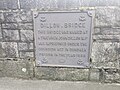 Dillon Bridge Plaque.jpg 4,032 × 3,024; 4.69 MB
-
 Disused River Suir railway bridge - geograph.org.uk - 1365432.jpg 480 × 640; 118 KB
-
 East Munster Way beside the River Suir - geograph.org.uk - 1398706.jpg 480 × 640; 343 KB
-
 Ferry Arriving At Passage East - geograph.org.uk - 403426.jpg 640 × 480; 67 KB
-
 Ferryhouse, Co. Tipperary, Ireland - panoramio.jpg 3,072 × 2,304; 3.38 MB
-
 Fishing trawler in harbour Cheekpoint village Co Waterford Ireland 2010.jpg 2,288 × 1,712; 818 KB
-
 Footpath beside the River Suir - geograph.org.uk - 1398723.jpg 640 × 480; 272 KB
-
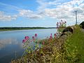
 Grazing land beside the River Suir - geograph.org.uk - 1398740.jpg 640 × 480; 285 KB
-

-
 Hotel Minella - geograph.org.uk - 1264099.jpg 640 × 480; 92 KB
-
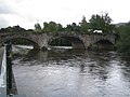
 Kilsheelan Bridge - geograph.org.uk - 264554.jpg 640 × 480; 118 KB
-
 Kilsheelan Bridge on the River Suir - geograph.org.uk - 1398661.jpg 640 × 480; 256 KB
-

-

-
 Old Ruin - geograph.org.uk - 486483.jpg 640 × 480; 69 KB
-
 Old Weir - geograph.org.uk - 1264100.jpg 640 × 480; 72 KB
-
 On Deck of S.S. Coningbeg (7179465339).jpg 2,000 × 1,526; 1.24 MB
-
 Passage East - geograph.org.uk - 1543200.jpg 640 × 480; 55 KB
-

-
 Red Iron Bridge - geograph.org.uk - 1388086.jpg 600 × 450; 221 KB
-
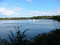 River Suir - geograph.org.uk - 484735.jpg 640 × 480; 61 KB
-
 River Suir - geograph.org.uk - 824356.jpg 624 × 464; 50 KB
-
 River Suir at Clonmel - geograph.org.uk - 216250.jpg 640 × 480; 102 KB
-
 River Suir at Fiodh Dúin (Fiddown) - geograph.org.uk - 261340.jpg 640 × 480; 37 KB
-
 River Suir at Kilsheelan Bridge - geograph.org.uk - 809409.jpg 640 × 480; 56 KB
-
 River Suir at Waterford - geograph.org.uk - 486460.jpg 640 × 480; 46 KB
-
 River Suir from Cahir Castle.jpg 2,816 × 2,112; 2.65 MB
-
 River Suir from Mount Congreve Gardens - geograph.org.uk - 216232.jpg 640 × 480; 104 KB
-
 River Suir in Cahir - geograph.org.uk - 264673.jpg 640 × 480; 144 KB
-
 River Suir near Ferryhouse - geograph.org.uk - 264664.jpg 640 × 480; 81 KB
-
 River Suir Waterford - geograph.org.uk - 486423.jpg 640 × 480; 58 KB
-
 River Suir, Drumdowney, Co. Kilkenny - geograph.org.uk - 1317661.jpg 640 × 420; 71 KB
-

-
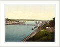 River Suir. Waterford. Co. Waterford Ireland.jpg 1,079 × 843; 117 KB
-
 Riverfront with crowds quays and Adelphi Hotel Waterford 1903 (6222126721).jpg 2,473 × 1,890; 2.62 MB
-
 Riverside Footpath - geograph.org.uk - 1264102.jpg 640 × 480; 87 KB
-

-
 Suir em Cahir.jpg 2,816 × 2,112; 2.88 MB
-
 Suir em Cahir2.jpg 2,816 × 2,112; 2.87 MB
-
 Suir in flood, Clonmel.jpg 3,888 × 5,184; 10.66 MB
-
 Suir river in flood.jpg 3,888 × 5,184; 7.9 MB
-

-
 The Red Iron Bridge - geograph.org.uk - 487026.jpg 640 × 480; 85 KB
-

-
 The River Suir, Waterford - geograph.org.uk - 1542871.jpg 640 × 480; 55 KB
-
 Thurles Bridge.jpg 2,592 × 1,944; 1.11 MB
-
 Thurles Cathedral as seen from the River Suir Bridge 2012 09 06.jpg 2,298 × 3,446; 5.81 MB
-
 Train going Dublin from Waterford.JPG 3,648 × 2,736; 1.9 MB
-
 Walk the plank in 2024 - Flickr - National Library of Ireland on The Commons.jpg 2,391 × 2,000; 1.17 MB
-

-

-

-

-

-
 Waterford 02.jpg 2,560 × 1,920; 281 KB
-
 Waterford city at night - geograph.org.uk - 1034017.jpg 640 × 285; 56 KB
-
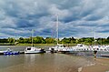
 Waterford City marina and River Suir - geograph.org.uk - 488367.jpg 640 × 480; 77 KB
-
 Waterford River Suir 1.jpg 4,542 × 2,820; 4.04 MB
-
 Waterford River Suir 2.jpg 4,554 × 2,985; 5.12 MB
-
 Waterford River Suir 3.jpg 4,571 × 2,906; 4.92 MB
-
 Waterford River Suir 4.jpg 4,572 × 2,904; 5.19 MB
-
 Waterford River Suir 5.jpg 4,579 × 3,141; 5.55 MB
-
 Woodstown Beach, Co. Waterford.jpg 4,032 × 3,024; 3.25 MB
-
 River Suir Waterford - geograph.org.uk - 690534.jpg 640 × 480; 54 KB
.jpg)
.jpg)


,_Mountain_Road_bridge_-_geograph.org.uk_-_260598.jpg)


.jpg)


_-_geograph.org.uk_-_261340.jpg)


.jpg)


