Category:Road altitude profiles
Media in category "Road altitude profiles"
The following 9 files are in this category, out of 9 total.
-
 Gel-jaun-pass.jpg 1,486 × 482; 89 KB
-
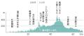
 Japan National Route 0219 Altitude diagram.png 874 × 352; 12 KB
-
 Japan National Route 0326 Altitude diagram.svg 414 × 176; 122 KB
-
 Japan National Route 265 Altitude diagram.svg 420 × 145; 166 KB
-
 Miyazaki Kagoshima prefectural route 2 Altitude diagram.svg 414 × 168; 83 KB
-
 Miyazaki prefectural route 27 Altitude diagram.svg 437 × 176; 114 KB
-
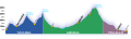 Perfil Trasandina.svg 1,000 × 293; 295 KB
-
 Trail Ridge Road - elevation profile, ft mi.gif 450 × 240; 15 KB
-
 Trail Ridge Road - elevation profile, m km.gif 450 × 240; 17 KB


