Category:Roads in Ireland

Highway system in the Republic of Ireland | |||||
| Upload media | |||||
| Instance of |
| ||||
|---|---|---|---|---|---|
| Location |
| ||||
| |||||
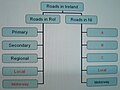
Images of roads of all types, road signposts, streets and street furniture on the island of Ireland (Q22890) (in either the Republic of Republic of Ireland (Q27) or in Northern Ireland (Q26)).

Subcategories
This category has the following 33 subcategories, out of 33 total.
A
B
- Bus lanes in Ireland (3 F)
C
D
E
F
- Forest roads in Ireland (6 F)
I
- Icy roads in Ireland (2 F)
L
M
- Mountain roads in Ireland (4 F)
N
P
R
S
- Scenic drives in Ireland (44 F)
- Snowy roads in Ireland (16 F)
T
- Tidal roads in Ireland (27 F)
V
- Views from roads in Ireland (49 F)
Media in category "Roads in Ireland"
The following 200 files are in this category, out of 254 total.
(previous page) (next page)-
 2018.01.30-Donabate-2.jpg 3,648 × 2,736; 3.88 MB
-
 A23 road (Ireland).jpg 1,048 × 880; 121 KB
-
 A42 road (Ireland).jpg 1,048 × 880; 122 KB
-
 A8 road (Ireland).jpg 1,048 × 880; 121 KB
-
 Allenwood (irl).jpg 3,888 × 1,895; 1.82 MB
-
 An Muileann gCearr.JPG 2,816 × 2,112; 883 KB
-
 AtlanticCorridor Dec09.png 390 × 593; 20 KB
-
 Bailieborough.jpg 625 × 460; 157 KB
-
 BallickmoylerOnTheR429road4086.jpg 3,888 × 2,592; 1.56 MB
-
 Ballyfarnon4032.jpg 3,888 × 2,592; 1.39 MB
-
 BlessingtonN81road5531w.jpg 2,592 × 1,944; 1.41 MB
-
-
 Caisleán Ghriaire (Castlegregory) - geograph.org.uk - 256130.jpg 640 × 480; 91 KB
-
 Carrigane 12 Feb 2009 b.jpg 959 × 649; 119 KB
-
 Carrigane xmas week 2008.jpg 1,024 × 768; 171 KB
-
 Coalbrook3458.jpg 3,880 × 2,481; 3.92 MB
-
 Coalbrook3459.jpg 3,888 × 2,592; 2.08 MB
-
 Coast path from Moville to Greencastle - geograph.org.uk - 125581.jpg 640 × 480; 146 KB
-
 Connemara landscape in The Inagh Valley.jpg 3,000 × 1,992; 2.05 MB
-
 Corlea Roadway.jpg 375 × 500; 142 KB
-
 CutLogs TaraHill Wexford Ireland Aug 2011.JPG 2,288 × 1,712; 806 KB
-
 Doonmanagh - geograph.org.uk - 258617.jpg 640 × 480; 117 KB
-
 Drombohilly Upper - geograph.org.uk - 263222.jpg 640 × 480; 130 KB
-
 Dsc (189710943).jpeg 1,600 × 1,065; 1.22 MB
-
 Military Road, Phoenix Park - geograph.org.uk - 304241.jpg 1,716 × 1,284; 147 KB
-
 Rathbeale Road, Swords, Co. Dublin - geograph.org.uk - 373505.jpg 640 × 425; 105 KB
-
 Dundrum Bypass sign.jpg 3,264 × 2,448; 3.06 MB
-

-
 Enfield0940.jpg 1,856 × 1,391; 711 KB
-
 Entering Scotstown - geograph.org.uk - 537342.jpg 640 × 480; 105 KB
-
 Fanore old famine road view.jpg 3,691 × 2,768; 2.67 MB
-
 Farm Track, Brays Head, Valencia - geograph.org.uk - 248719.jpg 640 × 424; 62 KB
-

-
 Fuchsia lined track - geograph.org.uk - 220023.jpg 600 × 450; 102 KB
-
 Gap of Dunloe.jpg 800 × 523; 110 KB
-
 Geill sli.jpg 500 × 327; 41 KB
-
 Glanmire Bypass looking south.JPG 4,000 × 3,000; 2.49 MB
-
 Glanmire Bypass winter.JPG 4,000 × 3,000; 3.01 MB
-
 Henebry's Cross - geograph.org.uk - 635153.jpg 640 × 426; 77 KB
-
 Hilly Irish country road.jpg 800 × 1,067; 799 KB
-
 IMG 1859bx.jpg 720 × 916; 238 KB
-
 IMG 3916w.JPG 2,592 × 1,944; 1.11 MB
-
 IMG M7test1816.JPG 2,589 × 1,670; 907 KB
-
 IMG R323EastAtKnock2720.jpg 3,888 × 2,592; 2.99 MB
-
 IMG R323Knock2719.jpg 3,888 × 2,592; 3.63 MB
-
 IMG R415Kildare0902.jpg 3,888 × 2,592; 2.61 MB
-
 IMG R449road2825a.jpg 3,888 × 2,592; 2.96 MB
-
 IMG SignR4492829.jpg 3,888 × 2,592; 2.52 MB
-
 IMG Tullow5575.jpg 2,211 × 1,629; 1.07 MB
-
 IMGDelgany07.jpg 3,888 × 2,592; 3.23 MB
-
 Ireland (3870393202).jpg 3,456 × 2,304; 3.15 MB
-
 Ireland coast sign.jpg 1,162 × 676; 115 KB
-
 Ireland May 2013.jpg 4,000 × 3,000; 4.44 MB
-
 Ireland Road Lanes-is.svg 118 × 268; 24 KB
-
 Ireland Road Lanes-ms.svg 118 × 268; 6 KB
-
 Ireland road lanes.png 118 × 268; 4 KB
-
 Ireland Road Lanes.svg 118 × 268; 6 KB
-
 Irish road sign.png 799 × 600; 706 KB
-
 J11 long shot.jpg 1,024 × 768; 175 KB
-
 Kildare 071.JPG 3,888 × 2,592; 4.89 MB
-
 KillaloeR463.jpg 2,964 × 2,228; 1.2 MB
-
 Killamery.JPG 3,730 × 1,617; 840 KB
-
 Killorglin2.jpg 2,848 × 2,136; 1.44 MB
-
 Killorglin7.jpg 2,848 × 2,136; 1.46 MB
-
 Lane at Polladooey - geograph.org.uk - 1302708.jpg 640 × 480; 140 KB
-

-
 Looking towards Partry Mountains - geograph.org.uk - 339880.jpg 640 × 480; 113 KB
-
 LuasGreenExt.JPG 3,727 × 2,230; 1.51 MB
-
 LuasGreenLineExt.JPG 3,872 × 2,260; 1.15 MB
-
 M11-Wicklow.jpg 4,000 × 3,000; 6.73 MB
-
 Midnight drive (251816183).jpg 3,008 × 1,606; 4 MB
-
 Minard West - geograph.org.uk - 258280.jpg 640 × 480; 105 KB
-
 MoneygallMainSt.JPG 3,878 × 1,659; 3.43 MB
-
 Motorway Services Ireland.png 215 × 125; 8 KB
-
 N21 Road with horse (Ireland).jpg 2,592 × 1,944; 473 KB
-
 N29 rcs IE.png 1,024 × 508; 29 KB
-
 N76road.JPG 3,879 × 2,481; 1.82 MB
-
 Neighbourhood watch, Ballykeeran - geograph.org.uk - 302672.jpg 640 × 480; 142 KB
-
 Nenagh to Limerick close to Silvermines.JPG 4,000 × 3,000; 2.94 MB
-
 New R639 signage.JPG 3,490 × 2,601; 1.38 MB
-
 NewblissTown.JPG 3,876 × 2,216; 5.16 MB
-
 O'bamaville.JPG 3,438 × 2,152; 1.04 MB
-
 On the green road, south of Formoyle. - geograph.org.uk - 65219.jpg 640 × 406; 100 KB
-
 Pay and Display sign with Tironian et for Irish agus.jpg 627 × 1,024; 117 KB
-
 Plassey House August 1972 (8976903361).jpg 2,447 × 1,099; 323 KB
-
 Portroe3736-1.jpg 3,311 × 2,141; 1.06 MB
-
 Portroe3739-1.jpg 3,106 × 2,039; 914 KB
-
 Priest's Leap - geograph.org.uk - 249968.jpg 640 × 480; 104 KB
-
 Priest's Leap road - geograph.org.uk - 249975.jpg 640 × 480; 82 KB
-
 QBCFoxrock.JPG 2,052 × 1,651; 1.11 MB
-
 R132roadIreland.jpg 3,353 × 1,699; 576 KB
-
 R192 Regional Route Shield Ireland.png 270 × 150; 5 KB
-
 R348 South West of Athenry.jpg 1,502 × 1,126; 978 KB
-
 R466atOBriensbridge.jpg 3,888 × 2,592; 1.71 MB
-
 R692road3468.jpg 3,888 × 2,592; 2.77 MB
-
 R750 Brittas Bay.jpg 3,888 × 2,592; 4.11 MB
-
 Rathnew Village.jpg 2,592 × 1,944; 1.13 MB
-
 Rhododendron infestation - geograph.org.uk - 235672.jpg 640 × 480; 91 KB
-
 Road at Clontyseer - geograph.org.uk - 1421944.jpg 640 × 479; 74 KB
-
 Road at Gort - geograph.org.uk - 791767.jpg 640 × 479; 76 KB
-
 Road at Laghty Barr - geograph.org.uk - 1118303.jpg 640 × 364; 63 KB
-
 Road at Midcut - geograph.org.uk - 1771696.jpg 640 × 480; 59 KB
-
 Road at Slievebuck - geograph.org.uk - 1006949.jpg 640 × 479; 46 KB
-
 Road at Tuam - geograph.org.uk - 1089508.jpg 640 × 479; 76 KB
-
 Road bend (3409509071).jpg 3,900 × 2,523; 4.58 MB
-
 Road by a cemetery (6197655213).jpg 800 × 594; 202 KB
-
 Road sign on the R639 north of Urlingford, Ireland - 20090502.jpg 3,781 × 2,920; 1.67 MB
-
 Road signs at Derrygorry - geograph.org.uk - 169364.jpg 640 × 479; 122 KB
-
 Road to Pollatomish - geograph.org.uk - 432631.jpg 640 × 386; 93 KB
-
 Roadside Hedge (4769154114).jpg 3,540 × 1,953; 341 KB
-
 Ruin and tree - geograph.org.uk - 1436749.jpg 640 × 426; 105 KB
-
 Schafe Strasse.JPG 1,600 × 1,200; 571 KB
-
 Shadow at the crossroads - dah de dah dah.jpg 2,000 × 1,535; 1.87 MB
-
 Sheep grazing - geograph.org.uk - 220020.jpg 427 × 600; 113 KB
-
 Sheep roads lambs.jpg 1,125 × 844; 191 KB
-
 Shinnahergoa Townland - geograph.org.uk - 167781.jpg 640 × 479; 111 KB
-
 Single Track Road, Pollatomish, Mayo - geograph.org.uk - 432645.jpg 640 × 480; 80 KB
-
 SouthDalysCrossM7.jpg 1,024 × 768; 351 KB
-
 Street (3608457288).jpg 4,600 × 3,068; 5.54 MB
-
 Sunset M8 bend.JPG 4,000 × 3,000; 2.86 MB
-
 Tallaght N81.jpg 4,864 × 2,736; 4.83 MB
-
 Tarmac fringe, or "on the edge" (2579072046).jpg 2,913 × 2,000; 9.31 MB
-
 The M8 through north County Cork.JPG 4,000 × 3,000; 2.32 MB
-
 The N8 Glanmire and Watergrasshill Bypasses merging at Killydonoghue.JPG 4,000 × 3,000; 2.89 MB
-
 The new N75.JPG 3,680 × 2,995; 2.05 MB
-
 The Sligo Way - geograph.org.uk - 487125.jpg 640 × 410; 109 KB
-
 Timolin.JPG 3,460 × 2,250; 1.74 MB
-
 Tipperary Border - geograph.org.uk - 33664.jpg 640 × 443; 75 KB
-
 Tower at Golden.JPG 4,000 × 3,000; 2.9 MB
-
 Track from Coombaha looking WSW - geograph.org.uk - 248884.jpg 422 × 640; 100 KB
-
 Track to Coombaha with small Lough - geograph.org.uk - 248889.jpg 640 × 427; 78 KB
-
 Twomileborris signage.JPG 2,724 × 3,000; 1.52 MB
-
 Uk carriageway guide.png 200 × 470; 3 KB
-
 Under Construction- Athlone-Ballinasloe.jpg 1,639 × 1,230; 627 KB
-
 View towards Carnane 1.JPG 448 × 336; 125 KB
-
 View towards Carnane.jpg 448 × 336; 122 KB
-
 View towards Williamstown.JPG 448 × 336; 124 KB
-
 Watergrasshill south.JPG 4,000 × 3,000; 2.91 MB
-
 WideningM50.JPG 3,888 × 2,592; 2.09 MB
-
 Wikipedia Irish road category proposal.jpg 2,067 × 1,552; 1.43 MB
-
 A healthy walk - geograph.org.uk - 239458.jpg 640 × 480; 133 KB
-
 Accommodation Road - geograph.org.uk - 1010869.jpg 640 × 480; 84 KB
-
 Ballyroon Mountain, Road to the top - geograph.org.uk - 15032.jpg 640 × 480; 326 KB
-
 Betaghstown Cross Roads - geograph.org.uk - 626508.jpg 640 × 480; 84 KB
-

-
 Boleybeg Cross Roads - geograph.org.uk - 714006.jpg 640 × 480; 82 KB
-
 Bridge at Cuilmullagh - geograph.org.uk - 486625.jpg 574 × 491; 119 KB
-
 Carrigans Townland - geograph.org.uk - 108218.jpg 640 × 479; 112 KB
-
 Clare Island. - geograph.org.uk - 296318.jpg 640 × 480; 111 KB
-
 Cnoc an Aifrinn - geograph.org.uk - 233266.jpg 640 × 480; 81 KB
-

-
 Connor Hill Road - geograph.org.uk - 259636.jpg 640 × 480; 99 KB
-
 Country lane at Lanmore - geograph.org.uk - 1404781.jpg 640 × 480; 79 KB
-
 Coxtown Townland - geograph.org.uk - 213232.jpg 640 × 479; 63 KB
-
 Cumberland Lodge - geograph.org.uk - 213214.jpg 640 × 288; 30 KB
-
 Dead end - Scarteen - geograph.org.uk - 292157.jpg 640 × 480; 79 KB
-
 Derrycloony - geograph.org.uk - 156665.jpg 640 × 479; 102 KB
-
 Derrycloony Townland - geograph.org.uk - 156663.jpg 640 × 479; 80 KB
-
 Derrygorey Townland, County Monaghan - geograph.org.uk - 174395.jpg 640 × 479; 85 KB
-
 Doo Lough - geograph.org.uk - 238985.jpg 640 × 480; 61 KB
-

-
 Drimminboy valley - geograph.org.uk - 263265.jpg 640 × 480; 117 KB
-
 Drombohilly Upper - geograph.org.uk - 263217.jpg 640 × 480; 114 KB
-
 Entering Emyvale - geograph.org.uk - 537428.jpg 640 × 480; 98 KB
-
 Famine relief road, Killary Harbour - geograph.org.uk - 201378.jpg 640 × 443; 102 KB
-

-
 Farm buildings - geograph.org.uk - 193015.jpg 640 × 215; 24 KB
-
 Farm laneway - geograph.org.uk - 635719.jpg 640 × 427; 92 KB
-
 Farm near Bantry - geograph.org.uk - 14840.jpg 640 × 480; 315 KB
-
 Farm Road near Na Gleannta Theas - geograph.org.uk - 17801.jpg 640 × 480; 479 KB
-
 Farming Country at Dun an Oir - geograph.org.uk - 17016.jpg 640 × 480; 458 KB
-
 Ferry queue - geograph.org.uk - 293682.jpg 640 × 480; 62 KB
-
 Flying - geograph.org.uk - 140048.jpg 640 × 480; 314 KB
-
 Forest escapee - geograph.org.uk - 549083.jpg 640 × 426; 92 KB
-
 Forest on Brandon Hill - geograph.org.uk - 490748.jpg 393 × 591; 169 KB
-
 Forest track - geograph.org.uk - 549080.jpg 640 × 436; 109 KB
-
 Garrynadur - geograph.org.uk - 256929.jpg 640 × 480; 67 KB
-
 Glenduff track - geograph.org.uk - 225103.jpg 640 × 480; 117 KB
-
 Glenpipe, Co. Kilkenny - geograph.org.uk - 213423.jpg 640 × 477; 103 KB
-
 Gurteen, R680 road - geograph.org.uk - 264660.jpg 640 × 480; 137 KB
-
 House at Whitehill, County Donegal - geograph.org.uk - 108225.jpg 640 × 479; 123 KB
-
 Inishkea South Island. - geograph.org.uk - 291260.jpg 640 × 411; 69 KB
-
 Intersection of the R559 and minor road - geograph.org.uk - 17010.jpg 640 × 480; 384 KB
-
 Jean's Cross - geograph.org.uk - 134442.jpg 640 × 480; 87 KB
-
 Kerry Way - geograph.org.uk - 36466.jpg 640 × 480; 77 KB
-
 Kerry Way - geograph.org.uk - 36545.jpg 640 × 480; 59 KB
-
 Kilnagullen Townland - geograph.org.uk - 628405.jpg 640 × 267; 29 KB
-

-

-
 Lane near Timoleague - geograph.org.uk - 239497.jpg 640 × 480; 148 KB
-

-

-
 Laneway at Feddyglass - geograph.org.uk - 213218.jpg 640 × 479; 57 KB
-
-
 Mam Clasach - geograph.org.uk - 220144.jpg 600 × 450; 60 KB
-
 Meennascarty - geograph.org.uk - 256242.jpg 640 × 480; 83 KB
-
 Minor Road - geograph.org.uk - 186893.jpg 640 × 480; 95 KB
-
 Minor Road and Farmland - geograph.org.uk - 16757.jpg 640 × 480; 551 KB
-
 Mountain Road - geograph.org.uk - 172909.jpg 640 × 480; 96 KB
-
 Near Leamacrossan Bridge, Inishowen - geograph.org.uk - 125572.jpg 640 × 480; 110 KB

.jpg)
.jpg)
.jpg)
.jpg)


_-_geograph.org.uk_-_256130.jpg)


.jpeg)


.jpg)


.jpg)


.jpg)


.jpg)


.jpg)
.jpg)


.jpg)


.jpg)


.jpg)


