Category:Roads in Westleton
Subcategories
This category has the following 4 subcategories, out of 4 total.
B
- Baker's Lane, Westleton (11 F)
- Blythburgh Road, Westleton (18 F)
D
R
- Reckford Road, Westleton (8 F)
Media in category "Roads in Westleton"
The following 65 files are in this category, out of 65 total.
-
 Access road to Potton Hall - geograph.org.uk - 3014315.jpg 640 × 480; 181 KB
-

-
 B1125 northeast of The Lambpits - geograph.org.uk - 3575867.jpg 3,353 × 2,572; 1.34 MB
-
 B1125 passes Low Barn - geograph.org.uk - 3575898.jpg 3,377 × 2,330; 944 KB
-
 B1125 traffic control east of Hinton Hall - geograph.org.uk - 3575850.jpg 3,648 × 2,736; 1.76 MB
-
 B1125 west of Brick Kiln Farm - geograph.org.uk - 3575858.jpg 3,097 × 2,327; 1.21 MB
-
 Byway to Hinton Corner Cottages - geograph.org.uk - 3357476.jpg 3,072 × 2,304; 1.71 MB
-
 Coming into Westleton from the north - geograph.org.uk - 2257615.jpg 640 × 480; 93 KB
-
 Country Lane to Dunwich - geograph.org.uk - 3023866.jpg 640 × 480; 237 KB
-
 Devil's Lane - geograph.org.uk - 2777093.jpg 3,072 × 2,304; 1.51 MB
-
 Devil's Lane, Darsham - geograph.org.uk - 3353015.jpg 3,072 × 2,304; 1.46 MB
-
 Ducks ahead, Westleton - geograph.org.uk - 2027853.jpg 640 × 480; 72 KB
-
 Dunwich Heath in late summer - geograph.org.uk - 2073837.jpg 640 × 480; 69 KB
-
 Entering Darsham on Wash Lane - geograph.org.uk - 3397973.jpg 2,877 × 1,719; 1.1 MB
-
 Entrance Road at Westleton Playing Field - geograph.org.uk - 3404892.jpg 3,072 × 2,304; 1.26 MB
-
 Entrance to Potton Hall - geograph.org.uk - 1906786.jpg 640 × 480; 225 KB
-
 Field entrance off Dunwich Road - geograph.org.uk - 3395840.jpg 3,072 × 2,304; 1.43 MB
-
 Field entrance off Lymballs Lane - geograph.org.uk - 3347090.jpg 3,072 × 2,304; 1.28 MB
-
 Field entrance off Wash Lane - geograph.org.uk - 3397987.jpg 3,072 × 2,304; 1.63 MB
-
 Footpath to Cuttons Hill - geograph.org.uk - 3358947.jpg 3,072 × 2,304; 1.38 MB
-
 Footpath to Cuttons Hill - geograph.org.uk - 3358948.jpg 2,304 × 3,072; 1.29 MB
-
 Footpath to Cuttons Hill - geograph.org.uk - 3358951.jpg 3,072 × 2,304; 1.5 MB
-
 Footpath to Cuttons Hill - geograph.org.uk - 3361740.jpg 3,072 × 2,304; 1.31 MB
-
 Footpath to Cuttons Hill - geograph.org.uk - 3361741.jpg 3,072 × 2,304; 1.39 MB
-
 Forest Road - geograph.org.uk - 3416306.jpg 3,072 × 2,304; 1.49 MB
-
 Forest Road and the footpath to Sandy Lane Farm - geograph.org.uk - 3416288.jpg 3,072 × 2,304; 1.52 MB
-

-
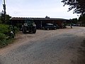 Garages and vehicle parking at Minsmere - geograph.org.uk - 4065351.jpg 1,536 × 1,152; 1.13 MB
-
 Grange View, Westleton - geograph.org.uk - 3377296.jpg 3,072 × 2,304; 1.29 MB
-
 Heath View ^ Blythburgh Road Postbox - geograph.org.uk - 3359136.jpg 3,072 × 2,304; 1.51 MB
-
 Heath View, Westleton - geograph.org.uk - 3359145.jpg 3,072 × 2,304; 1.17 MB
-
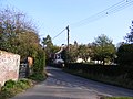
 In the Village of Westleton - geograph.org.uk - 3409632.jpg 640 × 480; 43 KB
-
 It's a winding road - geograph.org.uk - 2079154.jpg 640 × 480; 90 KB
-
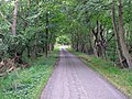
 Lane in Dunwich Forest - geograph.org.uk - 3744275.jpg 3,072 × 2,304; 1.85 MB
-
 Lane looking towards the crossroads - geograph.org.uk - 3744290.jpg 3,072 × 2,304; 1.89 MB
-
 Looking towards Dunwich Road - geograph.org.uk - 2763369.jpg 3,072 × 2,304; 1.28 MB
-
 Mill Street sign - geograph.org.uk - 3367704.jpg 2,931 × 2,201; 1.53 MB
-
 Mill Street, Westleton - geograph.org.uk - 3367706.jpg 3,072 × 2,304; 1.39 MB
-
 Mill Street, Westleton - geograph.org.uk - 3367710.jpg 3,072 × 2,304; 1.33 MB
-
 Mill Street, Westleton - geograph.org.uk - 3378354.jpg 3,072 × 2,304; 1.37 MB
-
 Minor Road - geograph.org.uk - 4589386.jpg 768 × 1,024; 342 KB
-
 Mobile Library in Westleton Street - geograph.org.uk - 2257458.jpg 640 × 480; 69 KB
-
 Road from RSPB Minsmere to Eastbridge - geograph.org.uk - 4139164.jpg 3,648 × 2,736; 4.92 MB
-
 Road from RSPB Minsmere to Eastbridge - geograph.org.uk - 4139169.jpg 3,648 × 2,736; 4.57 MB
-
 Road out of Westleton - geograph.org.uk - 3409654.jpg 640 × 480; 93 KB
-
 Road to Dunwich - geograph.org.uk - 2390586.jpg 800 × 531; 119 KB
-
 The Leaning Pole Of Westleton - geograph.org.uk - 1804823.jpg 1,200 × 1,600; 378 KB
-
 The road to Dunwich - geograph.org.uk - 3356245.jpg 3,072 × 2,304; 1.64 MB
-

-
 The Street, Westleton - geograph.org.uk - 2909789.jpg 1,600 × 934; 454 KB
-
 The village green at Westleton - geograph.org.uk - 2257599.jpg 640 × 480; 79 KB
-
 Travelling the old fashioned way - geograph.org.uk - 3912631.jpg 640 × 480; 104 KB
-
 Un-named lane east of Westleton Walks - geograph.org.uk - 3570229.jpg 3,397 × 2,381; 1.66 MB
-
 Un-named tracks north of Whin Covert - geograph.org.uk - 3570222.jpg 3,557 × 2,649; 2.11 MB
-
 Walkbarn Farm Lane ^ footpath ^ entrance to Kings Farm - geograph.org.uk - 3378315.jpg 3,072 × 2,304; 1.57 MB
-
 Walkbarn Farm Lane ^ Hardpiece Lane Bridleway - geograph.org.uk - 3378298.jpg 3,072 × 2,079; 1.62 MB
-
 Walkbarn Farm Lane ^ Hardpiece Lane Bridleway - geograph.org.uk - 3378340.jpg 3,072 × 2,304; 1.56 MB
-
 Walkbarn Farm Lane, Westleton - geograph.org.uk - 3377587.jpg 3,072 × 2,304; 1.51 MB
-
 Walkbarn Farm Lane, Westleton - geograph.org.uk - 3394708.jpg 3,072 × 2,304; 1.45 MB
-
 Wash Road - geograph.org.uk - 2777092.jpg 3,072 × 2,304; 1.49 MB
-
 Westleton Road - geograph.org.uk - 3402698.jpg 3,072 × 2,304; 1.37 MB
-
 Westleton Road - geograph.org.uk - 3402713.jpg 3,072 × 2,304; 1.23 MB
-
 Westleton Road - geograph.org.uk - 3404837.jpg 3,072 × 2,304; 1.02 MB
-
 Westleton Road - geograph.org.uk - 3409617.jpg 640 × 480; 36 KB
-
 Westleton Road crossroads at St Helena - geograph.org.uk - 3571350.jpg 3,541 × 2,584; 1.5 MB


