Category:Roadstead of Santa Panagia (Syracuse)
 | |||||
| Upload media | |||||
| Instance of | |||||
|---|---|---|---|---|---|
| Part of | |||||
| Location | Syracuse, Free Municipal Consortium of Syracuse, Sicily, Italy | ||||
 | |||||
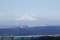
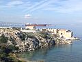
English: The Roadstead of Santa Panagia includes the Pier of petrochemical pole (the Pier is the longest in Europe with his 1,340 meters) and the "Refuge harbor" (a small bay which develops a length of 370 meters). The Roadstead belongs to the Maritime authority of Syracuse, which also controls the other two ports in the city: Porto Grande and Porto Piccolo
Italiano: La Rada di Santa Panagia comprende il Pontile del polo petrolchimico (il Pontile è il più lungo d'Europa con i suoi 1.340 metri) e il "Porto Rifugio" (una piccola insenatura che si sviluppa su una lunghezza di 370 metri). La rada appartiene all'Autorità marittima di Siracusa, che controlla anche gli altri due porti della città: il Porto Grande e il Porto Piccolo
Media in category "Roadstead of Santa Panagia (Syracuse)"
The following 15 files are in this category, out of 15 total.
-
 Cavalcavia Siracusa Nord II.jpg 1,028 × 418; 452 KB
-
 Cavalcavia Targia- Siracusa Nord.jpg 958 × 679; 593 KB
-
 In mezzo - dedicata a Laura Raggio - panoramio.jpg 2,848 × 2,136; 3.13 MB
-
 Pontile ISAB e penisola Magnisi.jpg 4,032 × 3,024; 1.59 MB
-
 Pontile Petrolchimico - Santa Panagia (1).jpg 1,856 × 1,392; 248 KB
-
 Pontile Petrolchimico - Santa Panagia (2).jpg 1,856 × 1,392; 171 KB
-
 Rada di Santa Panagia (1).jpg 1,856 × 1,392; 306 KB
-
 Rada di Santa Panagia (3).jpg 1,856 × 1,392; 222 KB
-
 Rada di Santa Panagia con Etna sullo sfondo (Siracusa).jpg 3,888 × 2,592; 4.15 MB
-
 Rada di Santa Panagia.jpg 1,024 × 768; 65 KB
-
 Rada di Santa Panagia.png 1,300 × 966; 2.85 MB
-
 Rada Santa Panagia 01.jpg 4,032 × 3,024; 3.32 MB
-
 Rada Santa Panagia 02.jpg 4,032 × 3,024; 1.8 MB
-
 Rada Santa Panagia 03.jpg 4,032 × 3,024; 3.64 MB
-
 Tonnara di Santa Panagia, scorcio.JPG 3,264 × 2,448; 2.06 MB


.jpg)
.jpg)
.jpg)
.jpg)
.jpg)


