Category:Rosemarkie (civil parish)
Scottish parish in Highland, Scotland, UK | |||||
| Upload media | |||||
| Instance of | |||||
|---|---|---|---|---|---|
| Named after | |||||
| Location |
| ||||
| Population |
| ||||
| Area |
| ||||
 | |||||
Subcategories
This category has the following 5 subcategories, out of 5 total.
Media in category "Rosemarkie (civil parish)"
The following 200 files are in this category, out of 645 total.
(previous page) (next page)-
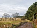
 "Access only" road approaching Boggiewell Farmhouse - geograph.org.uk - 4253474.jpg 1,400 × 1,051; 677 KB
-
 "Access only" road from Raddery - geograph.org.uk - 4253431.jpg 1,400 × 1,050; 586 KB
-
 "Access only" road from Raddery to Ordhill - geograph.org.uk - 4253438.jpg 1,400 × 1,050; 474 KB
-
 A bridge over the burn - geograph.org.uk - 3538642.jpg 640 × 427; 476 KB
-
 A Chewbacca satellite dish at Rosemarkie - geograph.org.uk - 5853532.jpg 1,024 × 683; 295 KB
-
 A fine pair, Rosemarkie - geograph.org.uk - 4888453.jpg 480 × 640; 93 KB
-
 A house sparrow at Chanonry Point - geograph.org.uk - 3178022.jpg 620 × 432; 228 KB
-
 A loop in the river in the Fairy Glen - geograph.org.uk - 3872079.jpg 1,400 × 1,051; 769 KB
-

-
 A small wood near the Old Mill of Raddery - geograph.org.uk - 2957732.jpg 1,600 × 1,200; 1,015 KB
-
 A starling at Chanonry Point - geograph.org.uk - 3178025.jpg 640 × 429; 249 KB
-
 A wet walk in Millbuie Forest - geograph.org.uk - 5300635.jpg 746 × 1,024; 154 KB
-
 A wet walk in Millbuie Forest - geograph.org.uk - 5300669.jpg 1,024 × 768; 181 KB
-
 A832 approaching Raddery turning - geograph.org.uk - 2455996.jpg 2,641 × 1,534; 478 KB
-
 AA box, Telephone box and Petrol pump - geograph.org.uk - 2177008.jpg 640 × 480; 120 KB
-
 Above Rosemarkie - geograph.org.uk - 3541474.jpg 640 × 427; 338 KB
-
 Access for Wester Raddery Farm - geograph.org.uk - 4739577.jpg 1,600 × 1,200; 815 KB
-
 Access to Wester Raddery Farm - geograph.org.uk - 4104420.jpg 1,400 × 1,050; 340 KB
-
 After the tidal surge - geograph.org.uk - 3786858.jpg 1,200 × 900; 563 KB
-
 Angel's Wings (Pleurocybella porrigens) - geograph.org.uk - 5110121.jpg 3,648 × 2,736; 6.65 MB
-
 Approaching Scart Craig - geograph.org.uk - 4791936.jpg 1,600 × 1,198; 831 KB
-
 Ardersier Bay from Hillockhead - geograph.org.uk - 5037141.jpg 3,679 × 2,456; 5.17 MB
-

-
 B9160 near Raddery - geograph.org.uk - 3717007.jpg 1,600 × 1,200; 389 KB
-
 Backroad entrance to Learnie Red Rock Cycle Trails - geograph.org.uk - 4763554.jpg 1,600 × 1,200; 831 KB
-
 Bank beside the track in Millbuie Forest - geograph.org.uk - 4166043.jpg 1,400 × 1,050; 600 KB
-
 Barn in the middle of nowhere - geograph.org.uk - 2456077.jpg 2,592 × 1,701; 1.08 MB
-
 Barns at Mount Pleasant - geograph.org.uk - 5367930.jpg 800 × 500; 105 KB
-
 Be Aware of Golf Balls - geograph.org.uk - 2336637.jpg 1,024 × 755; 315 KB
-
 Be aware the sea .... - geograph.org.uk - 1076366.jpg 640 × 480; 123 KB
-
 Beach at Chanonry Ness - geograph.org.uk - 5831682.jpg 1,600 × 1,065; 540 KB
-
 Beach at Chanonry Point - geograph.org.uk - 2893376.jpg 3,008 × 2,000; 1.32 MB
-
 Beach at Chanonry Point - geograph.org.uk - 5544315.jpg 1,600 × 942; 268 KB
-
 Beach at Rosemarkie - geograph.org.uk - 4658093.jpg 640 × 427; 88 KB
-
 Beach at Rosemarkie - geograph.org.uk - 4751364.jpg 682 × 1,024; 271 KB
-
 Beach at Rosemarkie Bay - geograph.org.uk - 5543712.jpg 1,024 × 680; 205 KB
-
 Beach below Eathie Fishing Station - geograph.org.uk - 971270.jpg 640 × 423; 121 KB
-
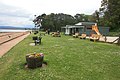 Beach Cafe, Rosemarkie - geograph.org.uk - 3539114.jpg 640 × 427; 334 KB
-
 Beach Café, Rosemarkie - geograph.org.uk - 3878803.jpg 1,024 × 768; 267 KB
-
 Beach north of Chanonry Point - geograph.org.uk - 5866474.jpg 1,024 × 678; 265 KB
-
 Beach on Chanonry Ness - geograph.org.uk - 1876633.jpg 640 × 480; 97 KB
-
 Beach south of Scart Craig - geograph.org.uk - 5587658.jpg 1,600 × 900; 422 KB
-
 Beach, Chanonry Ness - geograph.org.uk - 4751089.jpg 4,320 × 2,432; 5.45 MB
-
 Beach, Chanonry Ness - geograph.org.uk - 4751178.jpg 3,252 × 1,916; 2.32 MB
-
 Beachside Cafe, Rosemarkie - geograph.org.uk - 4101723.jpg 4,608 × 3,456; 3.13 MB
-
 Bedrock below Eathie Hill on the shore of the Black Isle - geograph.org.uk - 4628109.jpg 1,400 × 1,059; 471 KB
-
 Bedrock of Eathie Burn - geograph.org.uk - 5383481.jpg 1,600 × 1,201; 1.05 MB
-
 Beech trees in Craig Wood, Black Isle - geograph.org.uk - 5897220.jpg 1,600 × 1,066; 987 KB
-
 Benches on the Waterfront Rosemarkie - geograph.org.uk - 4930758.jpg 1,024 × 728; 533 KB
-

-
 Beside the track, Callachy Hill - geograph.org.uk - 5158427.jpg 1,600 × 1,202; 839 KB
-
 Beware of Golf Balls - geograph.org.uk - 3404021.jpg 1,138 × 1,600; 517 KB
-
 Beware of golf balls - geograph.org.uk - 5898129.jpg 777 × 1,024; 517 KB
-
 Black Isle coast north of Rosemarkie - geograph.org.uk - 5907573.jpg 1,600 × 1,063; 797 KB
-
 Black Isle farmland - geograph.org.uk - 2336582.jpg 1,200 × 686; 157 KB
-
 Black Isle landscape - geograph.org.uk - 4253453.jpg 1,400 × 730; 189 KB
-
 Black Isle trig points - geograph.org.uk - 4058813.jpg 640 × 360; 97 KB
-
 Board walk in Fairy Glen, Rosemarkie - geograph.org.uk - 6182784.jpg 1,600 × 900; 582 KB
-
 Boxing Day walkers at Rosemarkie - geograph.org.uk - 5635374.jpg 1,600 × 900; 558 KB
-
 Bridge near Rosemarkie - geograph.org.uk - 5614741.jpg 640 × 425; 76 KB
-
 Bridge on the approach to Rosemarkie - geograph.org.uk - 2177055.jpg 640 × 480; 170 KB
-
 Bridge over Markie Burn, Rosemarkie - geograph.org.uk - 3955532.jpg 640 × 480; 366 KB
-
 Bridge over Rosemarkie Burn - geograph.org.uk - 2456019.jpg 3,072 × 2,048; 2.6 MB
-

-
 Caird's Cave from the beach - geograph.org.uk - 4751338.jpg 4,320 × 2,432; 4.71 MB
-
 Cairds Cave, Rosemarkie. - geograph.org.uk - 4761181.jpg 1,600 × 1,204; 1.02 MB
-
 Camping ^ Caravanning Club Site, Rosemarkie - geograph.org.uk - 4101726.jpg 4,608 × 3,456; 3.13 MB
-
 Cathedral Square, Fortrose - geograph.org.uk - 4753967.jpg 2,560 × 1,638; 1.46 MB
-
 Channory Point ^ Inverness Firth - geograph.org.uk - 2256697.jpg 1,600 × 1,200; 329 KB
-
 Chanonry Lighthouse - geograph.org.uk - 4749130.jpg 4,608 × 3,456; 4.64 MB
-
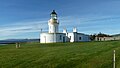 Chanonry Lighthouse - geograph.org.uk - 4751033.jpg 4,320 × 2,432; 4.47 MB
-
 Chanonry Lighthouse - geograph.org.uk - 6284430.jpg 1,280 × 845; 209 KB
-
 Chanonry Ness and Fortrose Bay at dusk - geograph.org.uk - 5240609.jpg 1,600 × 1,201; 276 KB
-
 Chanonry Ness and lighthouse at the point from Hillockhead - geograph.org.uk - 5037139.jpg 3,679 × 2,456; 4.47 MB
-
 Chanonry Ness, Fortrose and Rosemarkie Golf Course - geograph.org.uk - 5051956.jpg 2,452 × 1,640; 2.36 MB
-
 Chanonry Point - geograph.org.uk - 5212088.jpg 1,280 × 960; 816 KB
-
 Chanonry Point - geograph.org.uk - 5319338.jpg 2,000 × 1,333; 1.72 MB
-
 Chanonry Point and Lighthouse - geograph.org.uk - 5212107.jpg 1,280 × 960; 818 KB
-
 Chanonry Point and Rosemarkie Bay - geograph.org.uk - 4751236.jpg 3,888 × 2,592; 4.18 MB
-
 Chanonry Point lighthouse - geograph.org.uk - 4643451.jpg 1,600 × 1,200; 174 KB
-
 Chanonry Point lighthouse - geograph.org.uk - 4658120.jpg 640 × 427; 95 KB
-
 Chanonry Point Lighthouse - geograph.org.uk - 5031456.jpg 3,662 × 2,431; 4.32 MB
-
 Chanonry Point Lighthouse - geograph.org.uk - 5031465.jpg 4,917 × 3,050; 7.13 MB
-
 Chanonry Point Lighthouse - geograph.org.uk - 5051947.jpg 3,650 × 2,409; 5.39 MB
-
 Chanonry Point Lighthouse - geograph.org.uk - 5543702.jpg 1,024 × 678; 160 KB
-
 Chanonry Point Lighthouse - geograph.org.uk - 5544303.jpg 1,600 × 1,050; 191 KB
-
 Chanonry Point lighthouse - geograph.org.uk - 5607398.jpg 1,600 × 900; 320 KB
-
 Chanonry Point Lighthouse - geograph.org.uk - 5614682.jpg 640 × 425; 79 KB
-
 Chanonry Point Lighthouse - geograph.org.uk - 5614753.jpg 640 × 425; 80 KB
-
 Chanonry Point Lighthouse - geograph.org.uk - 5780201.jpg 4,181 × 3,135; 1.71 MB
-
 Chanonry Point lighthouse - geograph.org.uk - 5834984.jpg 1,600 × 1,065; 493 KB
-
 Chanonry Point Lighthouse - geograph.org.uk - 6275259.jpg 4,608 × 3,456; 3.91 MB
-
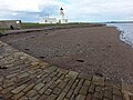 Chanonry Point Lighthouse and beach seen from the jetty - geograph.org.uk - 5553573.jpg 3,264 × 2,448; 3.29 MB
-
 Chanonry Point lighthouse at dusk - geograph.org.uk - 5157506.jpg 1,600 × 1,199; 262 KB
-
 Chanonry Point path - geograph.org.uk - 4751222.jpg 1,752 × 2,236; 1.79 MB
-
 Chanonry Point, Mobile ice cream seller - geograph.org.uk - 5031472.jpg 5,520 × 3,680; 7.17 MB
-
 Chanonry Point, Moray Firth, from the air - geograph.org.uk - 5888076.jpg 1,600 × 1,065; 309 KB
-

-
 Chanonry Sailing Club - geograph.org.uk - 4930516.jpg 1,024 × 768; 548 KB
-
 Chapter House, Fortrose Cathedral - geograph.org.uk - 5543408.jpg 1,600 × 1,200; 410 KB
-
 Christmas trees galore - geograph.org.uk - 3538633.jpg 640 × 427; 346 KB
-
 Church Street Fortrose - geograph.org.uk - 6346377.jpg 800 × 500; 73 KB
-
 Cliff near Learnie - geograph.org.uk - 3106671.jpg 480 × 640; 537 KB
-
 Coastal cliff below Hillockhead - geograph.org.uk - 3468529.jpg 1,200 × 900; 404 KB
-
 Coastal footpath from Scart Craig to Rosemarkie - geograph.org.uk - 4122337.jpg 1,400 × 1,054; 424 KB
-
 Coastal path, Rosemarkie Bay - geograph.org.uk - 5717519.jpg 640 × 480; 49 KB
-
 Coastline rocks, Scart Craig - geograph.org.uk - 5234562.jpg 1,600 × 900; 869 KB
-
 Coastline south of Scart Craig - geograph.org.uk - 5144764.jpg 1,600 × 900; 506 KB
-
 Cormorants on Scart Craig - geograph.org.uk - 4648710.jpg 1,600 × 1,200; 555 KB
-
 Cottage on the bend - geograph.org.uk - 3637164.jpg 640 × 449; 56 KB
-
 Craighead from Rosemarkie - geograph.org.uk - 5618511.jpg 640 × 425; 78 KB
-
 Craighead, Black Isle - geograph.org.uk - 5850368.jpg 3,968 × 2,976; 1.55 MB
-
 Cross of the Ness, Chanonry - geograph.org.uk - 4081950.jpg 2,900 × 2,124; 2.04 MB
-
 Cycling country - on National Cycle Route 1 - geograph.org.uk - 4104468.jpg 1,400 × 1,050; 430 KB
-
 Defibrillator at Gordon Memorial Hall, Rosemarkie - geograph.org.uk - 6023736.jpg 1,600 × 1,600; 663 KB
-
 Derelict barn at Hopefield - geograph.org.uk - 3558306.jpg 4,608 × 3,456; 4.66 MB
-
 Derelict steading at Hopefield - geograph.org.uk - 4142125.jpg 1,024 × 768; 265 KB
-
 Disconnected Steps - geograph.org.uk - 5614629.jpg 640 × 425; 79 KB
-
 Distinctive rock near Scart Craig - geograph.org.uk - 4145078.jpg 1,400 × 1,073; 787 KB
-
 Dog walking the length of Chanonry Ness - geograph.org.uk - 4737101.jpg 1,600 × 900; 565 KB
-
 Dolphin watching at Chanonry Point - geograph.org.uk - 5812884.jpg 1,600 × 1,000; 1.12 MB
-
 Drainage ditch at Wester Craiglands - geograph.org.uk - 4456949.jpg 1,024 × 576; 163 KB
-
 Driftwood below the Cliff - geograph.org.uk - 3106702.jpg 480 × 640; 566 KB
-
 Dunnock - geograph.org.uk - 5410832.jpg 640 × 480; 44 KB
-
 Early morning at Chanonry Point - geograph.org.uk - 5109384.jpg 3,615 × 2,169; 5.49 MB
-
 Easter Balmungie farm - geograph.org.uk - 5024057.jpg 3,678 × 2,456; 5.05 MB
-
 Eathie Bothy interior - geograph.org.uk - 3233689.jpg 640 × 425; 91 KB
-
 Eathie Burn - geograph.org.uk - 4343337.jpg 1,400 × 1,050; 476 KB
-
 Eathie Fishing Bothy - geograph.org.uk - 1196396.jpg 640 × 480; 91 KB
-
 Eathie Fishing Bothy - geograph.org.uk - 4889319.jpg 480 × 640; 71 KB
-
 Eathie Fishing Station - geograph.org.uk - 3939950.jpg 1,024 × 768; 279 KB
-
 Eathie Fishing Station - geograph.org.uk - 4562655.jpg 8,085 × 5,397; 4.28 MB
-
 Eathie Hill Radio transmitter - geograph.org.uk - 4888478.jpg 480 × 640; 40 KB
-
 Eathie Mains - geograph.org.uk - 2100296.jpg 800 × 531; 162 KB
-
 Eathie Mains farm - geograph.org.uk - 2175510.jpg 640 × 493; 87 KB
-
 Eden Lodge, Rosemarkie - geograph.org.uk - 2957704.jpg 1,600 × 1,114; 351 KB
-
 Edge of Rosemarkie beach - geograph.org.uk - 4890549.jpg 640 × 480; 66 KB
-
 End of the road, Chanonry Point - geograph.org.uk - 5544342.jpg 1,600 × 940; 252 KB
-
 Entrance to Muirhead Wood - geograph.org.uk - 4888470.jpg 480 × 640; 63 KB
-
 Entrance to track to Mount Pleasant Farm, near Fortrose - geograph.org.uk - 6170813.jpg 4,608 × 3,456; 3.86 MB
-
 Fairy footbridge - geograph.org.uk - 5212161.jpg 1,024 × 768; 447 KB
-
 Fairy Glen - geograph.org.uk - 4244387.jpg 800 × 600; 550 KB
-
 Fairy Glen - geograph.org.uk - 4244465.jpg 800 × 600; 528 KB
-
 Fairy Glen - geograph.org.uk - 4244469.jpg 800 × 600; 553 KB
-
 Fairy Glen Bridge - geograph.org.uk - 4930748.jpg 1,024 × 768; 586 KB
-
 Fairy Glen in autumn - geograph.org.uk - 5196745.jpg 1,200 × 675; 698 KB
-
 Fairy Glen Pond - geograph.org.uk - 5614733.jpg 640 × 425; 81 KB
-
 Fairy Glen Waterfall - geograph.org.uk - 5614704.jpg 640 × 425; 81 KB
-
 Fairy Glen Waterfall - geograph.org.uk - 5614709.jpg 640 × 425; 79 KB
-
 Fairyglen, Rosemarkie - geograph.org.uk - 5212158.jpg 1,280 × 960; 1.72 MB
-
 Farm buildings and tractor at Boggiewell - geograph.org.uk - 4253470.jpg 1,400 × 1,050; 331 KB
-
 Farm buildings at Cloy - geograph.org.uk - 4458118.jpg 1,024 × 576; 115 KB
-
 Farmland and trees at Hillockhead - geograph.org.uk - 2175901.jpg 640 × 480; 61 KB
-
 Farmland at Carse of Raddery - geograph.org.uk - 2957735.jpg 1,024 × 526; 106 KB
-
 Farmland at Eathie - geograph.org.uk - 2175528.jpg 640 × 480; 64 KB
-
 Farmland at Fortrose - geograph.org.uk - 5718314.jpg 640 × 480; 27 KB
-
 Farmland near Eathie - geograph.org.uk - 3558364.jpg 4,608 × 3,456; 3.38 MB
-
 Farmland near Eathie - geograph.org.uk - 971301.jpg 640 × 480; 81 KB
-
 Farmland near Flowerburn - geograph.org.uk - 2100228.jpg 800 × 531; 157 KB
-
 Farmland near Fortrose - geograph.org.uk - 1911334.jpg 640 × 426; 75 KB
-
 Farmland near Upper Eathie - geograph.org.uk - 2175525.jpg 640 × 480; 75 KB
-
 Field boundary at Fortrose - geograph.org.uk - 2957699.jpg 1,265 × 1,600; 694 KB
-
 Fields and woodland - geograph.org.uk - 2175522.jpg 640 × 480; 65 KB
-
 Fields at Boggiewell - geograph.org.uk - 4253444.jpg 1,400 × 1,050; 390 KB
-
 Fields at Eathie Mains - geograph.org.uk - 2100299.jpg 800 × 531; 157 KB
-
 Fields at Eathie Mains - geograph.org.uk - 3558370.jpg 4,608 × 3,456; 4.11 MB
-

-
 Fields at Hopefield - geograph.org.uk - 2176946.jpg 640 × 480; 71 KB
-
 Fields near Balmungie - geograph.org.uk - 5842649.jpg 2,592 × 1,944; 1.37 MB
-
 Fields of barley near Flowerburn House - geograph.org.uk - 3558326.jpg 4,608 × 3,456; 4.65 MB
-
 Flooded track, Millbuie Forest - geograph.org.uk - 5300652.jpg 1,024 × 768; 262 KB
-
 Footbridge Fairy Glen - geograph.org.uk - 4930722.jpg 1,024 × 768; 555 KB
-
 Footpath along the eastern shore of Chanonry Ness - geograph.org.uk - 3863050.jpg 1,400 × 1,050; 507 KB
-
 Footpath in Flowerburn Wood - geograph.org.uk - 4263530.jpg 1,400 × 1,050; 709 KB
-
 Footpath into Flowerburn Wood - geograph.org.uk - 4263520.jpg 1,400 × 1,050; 689 KB
-
 Footpath on Callachy Hill - geograph.org.uk - 4263546.jpg 1,400 × 1,050; 705 KB
-
 Footpath on Callachy Hill - geograph.org.uk - 4263584.jpg 1,400 × 1,053; 693 KB
-
 Footpath to the beach cafe - geograph.org.uk - 4751203.jpg 4,320 × 2,432; 4.63 MB
-
 Footpath to the shore below Brown Hill - geograph.org.uk - 6055459.jpg 768 × 1,024; 358 KB
-
 Foreshore north-east of Rosemarkie - geograph.org.uk - 3878809.jpg 1,024 × 768; 136 KB
-
 Forest edge - geograph.org.uk - 3795257.jpg 1,280 × 960; 1.48 MB
-
 Forest in the making - geograph.org.uk - 3795269.jpg 1,280 × 960; 1.25 MB
-
 Forest track - geograph.org.uk - 6232303.jpg 768 × 1,024; 231 KB
-
 Forest track - geograph.org.uk - 6232305.jpg 768 × 1,024; 194 KB
-
 Forest track - geograph.org.uk - 6232313.jpg 768 × 1,024; 256 KB
-
 Forest track at Muirhead Wood - geograph.org.uk - 6055467.jpg 1,024 × 768; 166 KB
-
 Forest track junction - geograph.org.uk - 3795147.jpg 1,280 × 960; 1.73 MB
-
 Forestry road in Blackstand Wood - geograph.org.uk - 3717001.jpg 1,600 × 1,200; 447 KB
-
 Forestry road into Muirhead Wood - geograph.org.uk - 2100246.jpg 800 × 531; 212 KB
-
 Former Black Isle Railway Underbridge - geograph.org.uk - 5783925.jpg 1,024 × 640; 316 KB
-
 Former Railway Line at Fortrose - geograph.org.uk - 5616711.jpg 640 × 425; 77 KB
-
 Fort George , Moray Firth - geograph.org.uk - 4977051.jpg 6,000 × 4,000; 5.98 MB
-
 Fort George from Chanonry Ness - geograph.org.uk - 5031451.jpg 3,663 × 2,424; 3.94 MB
-
 Fort George from Chanonry Point - geograph.org.uk - 5614636.jpg 640 × 425; 99 KB
-
 Fort George from Hillockhead - geograph.org.uk - 5037112.jpg 3,646 × 2,406; 4.65 MB
-
 Fort George from Hillockhead - geograph.org.uk - 5933669.jpg 1,600 × 1,063; 357 KB
-
 Fort George Inverness - geograph.org.uk - 4328610.jpg 4,180 × 2,499; 7.03 MB
-
 Fortrose , Chanonry Ness - geograph.org.uk - 4966806.jpg 6,000 × 4,000; 7.48 MB
-
 Fortrose , Chanonry Ness - geograph.org.uk - 4966807.jpg 5,673 × 3,782; 4.7 MB
-
 Fortrose , Chanonry Ness - geograph.org.uk - 4966808.jpg 6,000 × 4,000; 7.35 MB


_-_geograph.org.uk_-_5110121.jpg)


&diffonly=true&filefrom=Fortrose+%2C+Chanonry+Ness+-+geograph.org.uk+-+4966809.jpg#mw-category-media)