Category:Rothmannsthal
human settlement in Germany | |||||
| Upload media | |||||
| Instance of |
| ||||
|---|---|---|---|---|---|
| Location | Lichtenfels, Upper Franconia, Bavaria, Germany | ||||
| Elevation above sea level |
| ||||
 | |||||
Subcategories
This category has the following 2 subcategories, out of 2 total.
B
M
Media in category "Rothmannsthal"
The following 8 files are in this category, out of 8 total.
-
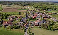 Rothmannsthal Luftbild-20210531-RM-170310.jpg 4,625 × 2,827; 7.91 MB
-
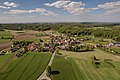 Rothmannsthal Luftbild-20210531-RM-170404.jpg 5,422 × 3,612; 8.63 MB
-
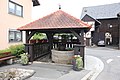 Rothmannsthal-Brunnen.jpg 6,720 × 4,480; 6.48 MB
-
 Rothmannsthal-Friedhofskapelle.jpg 4,212 × 5,616; 6.09 MB
-
 Rothmannsthal-Nebengebäude-242.jpg 5,376 × 3,584; 4.22 MB
-
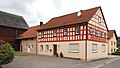 Rothmannsthal-Wohnstallhaus-243.jpg 5,544 × 3,119; 3.15 MB
-
 Steinsäule-Rothmannstal-P4202083.jpg 2,809 × 4,461; 6.2 MB
-
 Steinsäule-Rothmannstal-P4202085PS.jpg 2,403 × 4,451; 6.96 MB


