Category:Ruhland 700 Jahre, Kirchplatz
| Object location | | View all coordinates using: OpenStreetMap |
|---|
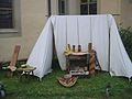
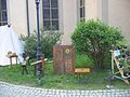
700-Jahr-Feier der Stadt Ruhland am Kirchplatz
editDiese Kategorie enthält den Teil der 700-Jahr-Feier der Stadt am Kirchplatz, wo ein Teil des historischen Marktes aufgebaut war
Media in category "Ruhland 700 Jahre, Kirchplatz"
The following 14 files are in this category, out of 14 total.
-
 Ruhland 700 Jahre, Kirchplatz 01.jpg 2,272 × 1,704; 483 KB
-
 Ruhland 700 Jahre, Kirchplatz 02.jpg 2,272 × 1,704; 699 KB
-
 Ruhland 700 Jahre, Kirchplatz 03.jpg 2,272 × 1,704; 413 KB
-
 Ruhland 700 Jahre, Kirchplatz 04.jpg 1,704 × 2,272; 562 KB
-
 Ruhland 700 Jahre, Kirchplatz 05.jpg 2,272 × 1,704; 394 KB
-
 Ruhland 700 Jahre, Kirchplatz 06.jpg 2,272 × 1,704; 480 KB
-
 Ruhland 700 Jahre, Kirchplatz 07.jpg 2,272 × 1,704; 651 KB
-
 Ruhland 700 Jahre, Kirchplatz 08.jpg 2,272 × 1,704; 586 KB
-
 Ruhland 700 Jahre, Kirchplatz 09.jpg 2,272 × 1,704; 613 KB
-
 Ruhland 700 Jahre, Kirchplatz 10.jpg 2,272 × 1,704; 527 KB
-
 Ruhland 700 Jahre, Kirchplatz 11.jpg 2,272 × 1,704; 661 KB
-
 Ruhland 700 Jahre, Kirchplatz 12.jpg 2,272 × 1,704; 558 KB
-
 Ruhland 700 Jahre, Kirchplatz 13.jpg 2,272 × 1,704; 590 KB
-
 Ruhland 700 Jahre, Kirchplatz 14.jpg 2,272 × 1,704; 507 KB


