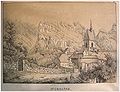
Category:Ruines du château de St-Ursanne - Moyen Age (Saint-Ursanne)
| Object location | | View all coordinates using: OpenStreetMap |
|---|
archaeological site in Saint-Ursanne in the canton Jura, Switzerland  | |||||
| Upload media | |||||
| Instance of | |||||
|---|---|---|---|---|---|
| Part of | |||||
| Location | Saint-Ursanne, Clos du Doubs, Porrentruy District, Jura, Switzerland | ||||
| Heritage designation | |||||
 | |||||
Media in category "Ruines du château de St-Ursanne - Moyen Age (Saint-Ursanne)"
This category contains only the following file.
-
 St Ursanne avis.jpg 1,983 × 1,518; 2.59 MB