Category:Sépultures mégalithiques de la Butte aux Gorzeaux
| Object location | | View all coordinates using: OpenStreetMap |
|---|
|
This building is classé au titre des monuments historiques de la France. It is indexed in the base Mérimée, a database of architectural heritage maintained by the French Ministry of Culture, under the reference PA00108805
|
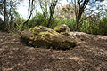
tumulus in Saint-Joachim, France  | |||||
| Upload media | |||||
| Instance of |
| ||||
|---|---|---|---|---|---|
| Location | Saint-Joachim, Loire-Atlantique, Pays de la Loire, Metropolitan France, France | ||||
| Street address |
| ||||
| Heritage designation |
| ||||
 | |||||
Media in category "Sépultures mégalithiques de la Butte aux Gorzeaux"
The following 7 files are in this category, out of 7 total.
-
 Butte aux Gorzeaux - Sépultures méglithiques - 1.jpg 6,048 × 4,032; 20.21 MB
-
 Butte aux Gorzeaux - Sépultures méglithiques - 2.jpg 6,048 × 4,032; 16.36 MB
-
 Dolmen Butte Gorzeaux 1.JPG 5,184 × 3,456; 10.38 MB
-
 Dolmen Butte Gorzeaux 2.JPG 4,247 × 3,185; 15.47 MB
-
 Dolmen Butte Gorzeaux 3.JPG 4,890 × 3,260; 16.94 MB
-
 Dolmen1-butte de Gorzeaux Brière (44).JPG 3,872 × 2,592; 4.92 MB
-
 Dolmen2-butte de Gorzeaux Brière (44).JPG 3,872 × 2,592; 4.85 MB


.JPG)
.JPG)