Category:SVG labeled maps of administrative divisions of Namibia (location map scheme)


.svg)


_(Paris_zoom).svg)
.svg)
,_administrative_divisions_-_de_-_colored_(multizoom).svg)
_-_colored.svg)
.svg)
,_administrative_divisions_-_Nmbrs_(multizoom).svg)
,_administrative_divisions_-_de_-_colored.svg)
_-_de_-_colored.svg)

.svg)

.svg)
Media in category "SVG labeled maps of administrative divisions of Namibia (location map scheme)"
The following 9 files are in this category, out of 9 total.
-
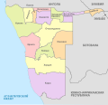
 Namibia 14 regions-numbered.svg 700 × 675; 120 KB
-
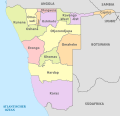 Namibia, administrative divisions - de - colored.svg 1,300 × 1,252; 202 KB
-
 Namibia, administrative divisions - de - monochrome.svg 1,300 × 1,252; 203 KB
-
 Namibia, administrative divisions - et - colored.svg 1,300 × 1,252; 258 KB
-
 Namibia, administrative divisions - mk - colored.svg 1,300 × 1,252; 279 KB
-
 Namibia, administrative divisions - Nmbrs - colored mk.svg 1,300 × 1,252; 206 KB
-
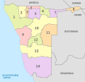 Namibia, administrative divisions - Nmbrs - colored.svg 1,300 × 1,252; 202 KB
-
 Namibia, administrative divisions - Nmbrs - monochrome.svg 1,300 × 1,252; 203 KB
-
 Namibia, administrative divisions - ru - colored.svg 1,300 × 1,252; 479 KB


