Category:SVG locator maps of planning areas of Singapore (location map scheme)
Media in category "SVG locator maps of planning areas of Singapore (location map scheme)"
The following 55 files are in this category, out of 55 total.
-
 Ang Mo Kio location.svg 3,247 × 2,061; 628 KB
-
 Bedok location.svg 3,247 × 2,061; 632 KB
-
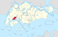
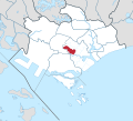
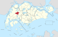
 Bishan in Central Region, Singapore.svg 356 × 322; 342 KB
-
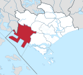
 Boon Lay location.svg 3,247 × 2,061; 629 KB
-
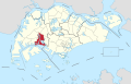
 Bukit Batok location.svg 3,247 × 2,061; 629 KB
-
 Bukit Merah in Central Region, Singapore.svg 356 × 322; 343 KB
-
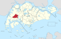
 Bukit Panjang location.svg 3,247 × 2,061; 629 KB
-
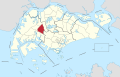
 Bukit Timah in Central Region, Singapore.svg 356 × 322; 343 KB
-
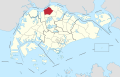
 Central Water Catchment location.svg 3,247 × 2,061; 660 KB
-
 Changi Bay location.svg 3,247 × 2,061; 635 KB
-
 Changi location.svg 3,247 × 2,061; 632 KB
-
 Choa Chu Kang location.svg 3,247 × 2,061; 628 KB
-
 Clementi location.svg 3,247 × 2,061; 630 KB
-
 Downtown Core in Central Region, Singapore.svg 356 × 322; 343 KB
-
 Geylang in Central Region, Singapore.svg 356 × 322; 343 KB
-
 Hougang location.svg 3,247 × 2,061; 629 KB
-
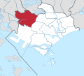
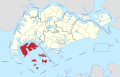
 Jurong East location.svg 3,247 × 2,061; 650 KB
-
 Jurong West location.svg 3,247 × 2,061; 628 KB
-
 Kallang in Central Region, Singapore.svg 356 × 322; 343 KB
-
 Lim Chu Kang location.svg 3,247 × 2,061; 633 KB
-
 Mandai location.svg 3,247 × 2,061; 628 KB
-
 Marina East in Central Region, Singapore.svg 356 × 322; 343 KB
-
 Marina South in Central Region, Singapore.svg 356 × 322; 343 KB
-
 Marine Parade in Central Region, Singapore.svg 356 × 322; 343 KB
-
 Museum in Central Region, Singapore.svg 356 × 322; 343 KB
-
 Newton in Central Region, Singapore.svg 356 × 322; 343 KB
-
 North-Eastern Islands location.svg 3,247 × 2,061; 650 KB
-
 Novena in Central Region, Singapore.svg 356 × 322; 342 KB
-
 Orchard in Central Region, Singapore.svg 356 × 322; 343 KB
-
 Outram in Central Region, Singapore.svg 356 × 322; 343 KB
-
 Pasir Ris location.svg 3,247 × 2,061; 631 KB
-
 Paya Lebar location.svg 3,247 × 2,061; 630 KB
-
 Pioneer location.svg 3,247 × 2,061; 630 KB
-
 Punggol location.svg 3,247 × 2,061; 629 KB
-
 Queenstown in Central Region, Singapore.svg 356 × 322; 343 KB
-
 River Valley in Central Region, Singapore.svg 356 × 322; 343 KB
-
 Rochor in Central Region, Singapore.svg 356 × 322; 343 KB
-
 Seletar location.svg 3,247 × 2,061; 630 KB
-
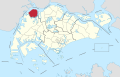
 Sembawang location.svg 3,247 × 2,061; 628 KB
-
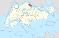
 Sengkang location.svg 3,247 × 2,061; 629 KB
-
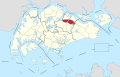
 Serangoon location.svg 3,247 × 2,061; 628 KB
-
 Simpang in Singapore.svg 3,247 × 2,061; 633 KB
-
 Singapore River in Central Region, Singapore.svg 356 × 322; 343 KB
-
 Southern Islands in Central Region, Singapore.svg 356 × 322; 343 KB
-
 Straits View in Central Region, Singapore.svg 356 × 322; 343 KB
-
 Sungei Kadut location.svg 3,247 × 2,061; 633 KB
-
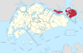
 Tampines location.svg 3,247 × 2,061; 629 KB
-
 Tanglin in Central Region, Singapore.svg 356 × 322; 343 KB
-
 Tengah location.svg 3,247 × 2,061; 628 KB
-
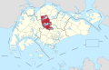
 Toa Payoh in Central Region, Singapore.svg 356 × 322; 343 KB
-
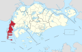 Tuas location.svg 3,247 × 2,061; 642 KB
-
 Western Islands location.svg 3,247 × 2,061; 672 KB
-
 Western Water Catchment location.svg 3,247 × 2,061; 690 KB
-
 Woodlands location.svg 3,247 × 2,061; 631 KB
-
 Yishun location.svg 3,247 × 2,061; 634 KB


