Category:SVG locator maps of provinces of Indonesia (location map scheme)

|
SVG maps in this category are part of a locator map series applying the (de) widespread location map scheme. Please see root category to browse for more. |
.svg)
.svg)
.svg)
.svg)
.svg)
.svg)
.svg)
Locator maps design recommendations ▼ | |
|---|---|
Principles
Design Guidelines are based on ▸location map design of the German map shop (in German). It's preferable to derive new locator maps from existing location maps. Please keep both size and ratio in this case. Thus the new locator maps may still be applied as location map (▸Guide). Marker color is supposed to be darkred. Waterbodies may be transparent, to show other objects better. Please be aware that this guide is only a recommendation. It’s not an inevitable law!
Highlight small areas
“Remote” areas and mini maps
Mini maps show where the depicted area actually is situated. Check out ▸Vorlage:Positionskarte+ (in German) and ▸Modèle:Carte en coin (in French) of how to insert a mini map in virtually every map.
Disputed areas
Greyed special objects
Backgrounds
|

-en.svg)

.svg)
.svg)
.svg)

_(US48).svg)
_(small_islands_magnified)_(-mini_map_-rivers).svg)
.svg)
_(extra_close)_(US48).svg)
.svg)
_(zoom).svg)

.svg)


_(UNMIK).svg)
.svg)
_(disputed_hatched).svg)
_(claimed_and_disputed_hatched).svg)
.svg)
.svg)
_(%2Ball_claims_hatched).svg)

.svg)
_(shade).svg)
_(shade)_(special_marker).svg)
_(-mini_map).svg)
_(-mini_map).svg)
_(-mini_map).svg)


.svg)

.svg)

Subcategories
This category has the following 2 subcategories, out of 2 total.
Media in category "SVG locator maps of provinces of Indonesia (location map scheme)"
The following 62 files are in this category, out of 62 total.
-
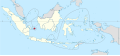
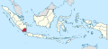
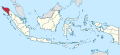 Aceh in Indonesia.svg 982 × 450; 793 KB
-
 Aceh in Indonesien.png 275 × 105; 23 KB
-
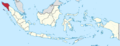
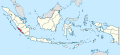
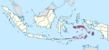
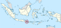 Bali in Indonesia (special marker).svg 982 × 450; 793 KB
-
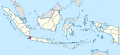
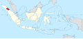
 Bali in Indonesia.svg 982 × 450; 792 KB
-
 Bangka in the United States of Indonesia.svg 786 × 361; 676 KB
-
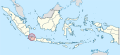
 Bangka-Belitung in Indonesia.svg 982 × 450; 793 KB
-
 Banjar in the United States of Indonesia.svg 786 × 361; 676 KB
-
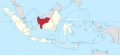
 Banten in Indonesia.svg 982 × 450; 792 KB
-
 Belitung in the United States of Indonesia.svg 786 × 361; 676 KB
-
 Bengkulu in Indonesia.svg 982 × 450; 793 KB
-
 Central Java in Indonesia.svg 982 × 450; 792 KB
-
 Central Java in the United States of Indonesia.svg 786 × 361; 676 KB
-
 Central Kalimantan in Indonesia.svg 982 × 450; 792 KB
-
 Central Sulawesi in Indonesia.svg 982 × 450; 792 KB
-
 East Borneo in the United States of Indonesia.svg 786 × 361; 676 KB
-
 East Indonesia in the United States of Indonesia.svg 786 × 361; 676 KB
-
 East Java in Indonesia.svg 982 × 450; 792 KB
-
 East Java in the United States of Indonesia.svg 786 × 361; 676 KB
-
 East Kalimantan in Indonesia.svg 982 × 450; 792 KB
-
 East Nusa Tenggara in Indonesia.svg 982 × 450; 792 KB
-
 East Sumatra in the United States of Indonesia.svg 786 × 361; 676 KB
-
 Gorontalo in Indonesia.svg 982 × 450; 792 KB
-
 Great Dayak in the United States of Indonesia.svg 786 × 361; 676 KB
-
 Jakarta Special Capital Region in Indonesia (special marker).svg 982 × 450; 793 KB
-
 Jakarta Special Capital Region in Indonesia.svg 982 × 450; 793 KB
-
 Jambi in Indonesia.svg 982 × 450; 793 KB
-
 Kotawaringin in the United States of Indonesia.svg 786 × 361; 676 KB
-
 Lampung in Indonesia.svg 982 × 450; 793 KB
-
 Madura in the United States of Indonesia.svg 786 × 361; 676 KB
-
 Maluku in Indonesia (special marker).svg 982 × 450; 828 KB
-
 Maluku in Indonesia.svg 982 × 450; 792 KB
-
 North Kalimantan in Indonesia.svg 982 × 450; 792 KB
-
 North Maluku in Indonesia.svg 982 × 450; 792 KB
-
 North Sulawesi in Indonesia.svg 982 × 450; 792 KB
-
 North Sumatra in Indonesia.svg 982 × 450; 793 KB
-
 Papua in Indonesia.svg 982 × 450; 912 KB
-
 Papua Pegunungan in Indonesia.svg 982 × 450; 792 KB
-
 Papua Selatan in Indonesia.svg 982 × 450; 792 KB
-
 Papua Tengah in Indonesia.svg 982 × 450; 792 KB
-
 Pasundan in the United States of Indonesia.svg 786 × 361; 676 KB
-
 Province of Papua in Indonesia.svg 982 × 450; 792 KB
-
 R.I. in the United States of Indonesia.svg 786 × 361; 676 KB
-
 Riau in Indonesia.svg 982 × 450; 793 KB
-
 Riau in the United States of Indonesia.svg 786 × 361; 676 KB
-
 Riau Islands in Indonesia (special marker).svg 982 × 450; 804 KB
-
 Riau Islands in Indonesia.svg 982 × 450; 793 KB
-
 South East Sulawesi in Indonesia.svg 982 × 450; 792 KB
-
 South Kalimantan in Indonesia.svg 982 × 450; 792 KB
-
 South Sulawesi in Indonesia.svg 982 × 450; 792 KB
-
 South Sumatra in Indonesia.svg 982 × 450; 793 KB
-
 South Sumatra in the United States of Indonesia.svg 786 × 361; 676 KB
-
 Southeast Borneo Federation in the United States of Indonesia.svg 786 × 361; 676 KB
-
 Southwest Papua in Indonesia.svg 982 × 450; 792 KB
-
 Special Region of Yogyakarta in Indonesia (special marker).svg 982 × 450; 793 KB
-
 Special Region of Yogyakarta in Indonesia.svg 982 × 450; 793 KB
-
 West Borneo in the United States of Indonesia.svg 786 × 361; 676 KB
-
 West Java in Indonesia.svg 982 × 450; 793 KB
-
 West Kalimantan in Indonesia.svg 982 × 450; 792 KB
-
 West Nusa Tenggara in Indonesia.svg 982 × 450; 792 KB
-
 West Papua in Indonesia.svg 982 × 450; 792 KB
-
 West Sulawesi in Indonesia.svg 982 × 450; 792 KB
-
 West Sumatra in Indonesia.svg 982 × 450; 793 KB

.svg)


.svg)


.svg)


.svg)


.svg)


