Category:SVG maps of South Ossetia
Subcategories
This category has the following 3 subcategories, out of 3 total.
Media in category "SVG maps of South Ossetia"
The following 13 files are in this category, out of 13 total.
-
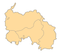 Districts South Ossetia.svg 1,006 × 910; 40 KB
-
 Dzau district.svg 1,006 × 910; 33 KB
-
 Leningor district.svg 1,006 × 910; 33 KB
-
 Map of South Ossetia (1992-2008 borders).svg 1,035 × 768; 181 KB
-
 South Ossetia in Asia (relief) (-mini map).svg 1,181 × 1,050; 5.66 MB
-
 South Ossetia in Asia (relief) (special marker) (-mini map).svg 1,181 × 1,050; 5.66 MB
-
 South Ossetia location map (semi-secession).svg 1,087 × 1,013; 1.35 MB
-
 South Ossetia location map(riv on).svg 1,000 × 910; 67 KB
-
 South Ossetia location map.svg 600 × 531; 140 KB
-
 South Ossetia percentage ethnic Georgians per district 2015 census.svg 1,006 × 910; 40 KB
-
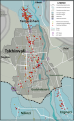 Tskhinvali - 2008 war damages.svg 814 × 1,321; 397 KB
-
 Tskhinvali district.svg 1,006 × 910; 32 KB
-
 Znaur district.svg 1,006 × 910; 32 KB


.svg)
_(-mini_map).svg)
_(special_marker)_(-mini_map).svg)
.svg)
.svg)


