Category:SVG maps of historic counties of England in Sect 5
Media in category "SVG maps of historic counties of England in Sect 5"
The following 33 files are in this category, out of 33 total.
-
 Bedfordshire Brit Isles Sect 5.svg 809 × 743; 939 KB
-
 Berkshire Brit Isles Sect 5.svg 809 × 743; 939 KB
-
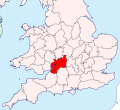
 Buckinghamshire Brit Isles Sect 5.svg 809 × 743; 939 KB
-
 Cambridgeshire Brit Isles Sect 5.svg 809 × 743; 939 KB
-
 Cheshire Brit Isles Sect 5.svg 809 × 743; 939 KB
-
 Cornwall Brit Isles Sect 5.svg 809 × 743; 939 KB
-
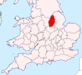
 Derbyshire Brit Isles Sect 5.svg 809 × 743; 939 KB
-
 Devon Brit Isles Sect 5.svg 809 × 743; 939 KB
-
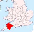
 Dorset Brit Isles Sect 5.svg 809 × 743; 939 KB
-
 Essex Brit Isles Sect 5.svg 809 × 743; 939 KB
-
 Gloucestershire Brit Isles Sect 5.svg 809 × 743; 939 KB
-
 Hampshire Brit Isles Sect 5.svg 809 × 743; 939 KB
-
 Herefordshire Brit Isles Sect 5.svg 809 × 743; 939 KB
-
 Hertfordshire Brit Isles Sect 5.svg 809 × 743; 939 KB
-
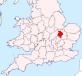 Huntingdonshire Brit Isles Sect 5.svg 809 × 743; 939 KB
-
 Kent Brit Isles Sect 5.svg 809 × 743; 939 KB
-
 Leicestershire Brit Isles Sect 5.svg 809 × 743; 939 KB
-
 Lincolnshire Brit Isles Sect 5.svg 809 × 743; 939 KB
-
 Middlesex Brit Isles Sect 5.svg 809 × 743; 939 KB
-
 Norfolk Brit Isles Sect 5.svg 809 × 743; 939 KB
-
 Northamptonshire Brit Isles Sect 5.svg 809 × 743; 939 KB
-
 Nottinghamshire Brit Isles Sect 5.svg 809 × 743; 939 KB
-
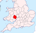
 Oxfordshire Brit Isles Sect 5.svg 809 × 743; 939 KB
-
 Rutland Brit Isles Sect 5.svg 809 × 743; 939 KB
-
 Shropshire Brit Isles Sect 5.svg 809 × 743; 939 KB
-
 Somerset Brit Isles Sect 5.svg 809 × 743; 939 KB
-
 Staffordshire Brit Isles Sect 5.svg 809 × 743; 939 KB
-
 Suffolk Brit Isles Sect 5.svg 809 × 743; 939 KB
-
 Surrey Brit Isles Sect 5.svg 809 × 743; 939 KB
-
 Sussex Brit Isles Sect 5.svg 809 × 743; 939 KB
-
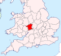
 Warwickshire Brit Isles Sect 5.svg 809 × 743; 939 KB
-
 Wiltshire Brit Isles Sect 5.svg 809 × 743; 939 KB
-
 Worcestershire Brit Isles Sect 5.svg 809 × 743; 939 KB


