Category:SVG maps of historic counties of England in Sect 6
Media in category "SVG maps of historic counties of England in Sect 6"
The following 11 files are in this category, out of 11 total.
-
 Cheshire Brit Isles Sect 6.svg 545 × 593; 938 KB
-
 Cornwall Brit Isles Sect 6.svg 545 × 593; 938 KB
-
 Devon Brit Isles Sect 6.svg 545 × 593; 938 KB
-
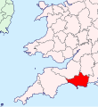 Dorset Brit Isles Sect 6.svg 545 × 593; 938 KB
-
 Gloucestershire Brit Isles Sect 6.svg 545 × 593; 938 KB
-
 Herefordshire Brit Isles Sect 6.svg 545 × 593; 938 KB
-
 Shropshire Brit Isles Sect 6.svg 545 × 593; 938 KB
-
 Somerset Brit Isles Sect 6.svg 545 × 593; 938 KB
-
 Staffordshire Brit Isles Sect 6.svg 545 × 593; 938 KB
-
 Wiltshire Brit Isles Sect 6.svg 545 × 593; 938 KB
-
 Worcestershire Brit Isles Sect 6.svg 545 × 593; 938 KB


