Category:SVG maps of provinces of Bulgaria
English: Maps of the Provinces of Bulgaria — the former Bulgarian Districts or okrug (pre-1999).
- NOTE: since 1999 the primary Bulgarian District subdivisions were renamed Provinces of Bulgaria.
- Bulgaria has been divided into 28 Provinces (Bulgarian: области, oblasti; singular област, oblast ) — which correspond approximately to the former 28 Districts (okrugs) that existed before 1987. Those old 'District names' are still used for Commons image subcategories, instead of current-correct 'Province names' — until updated.
- For the current-only matching category in wikipedia (english text), see: Category: Provinces of Bulgaria'.
Subcategories
This category has the following 2 subcategories, out of 2 total.
Media in category "SVG maps of provinces of Bulgaria"
The following 6 files are in this category, out of 6 total.
-
 Bulgaria Blagoevgrad Province topographic map.svg 550 × 500; 7.08 MB
-
 Bulgaria Lovech Province topographic map bg.svg 1,684 × 1,200; 9.08 MB
-
 Bulgaria Pernik Province topographic map bg.svg 2,038 × 1,700; 6.03 MB
-
 Bulgaria Pernik Province topographic map.svg 2,038 × 1,700; 5.92 MB
-
 Bulgaria Stolichna Municipality geographic map bg.svg 1,000 × 1,050; 9.86 MB
-
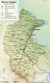 Bulgaria-Oblast-Vidin-geographic-map-bg.svg 750 × 1,250; 1.71 MB


