Category:SVG maps of the divisions of the Polish-Lithuanian Commonwealth
Media in category "SVG maps of the divisions of the Polish-Lithuanian Commonwealth"
The following 10 files are in this category, out of 10 total.
-
 Podział administracyjny I RP.svg 1,061 × 931; 4.26 MB
-
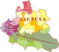 ATR dalys.svg 1,047 × 916; 202 KB
-
 Podział administracyjny I RP 2 (2.0).svg 1,047 × 916; 3.05 MB
-
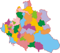 Podział administracyjny I RP 2.svg 1,047 × 916; 258 KB
-
 Podział administracyjny I RP-es.svg 1,060 × 930; 8.01 MB
-
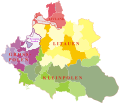 Prowincje I RP de.svg 855 × 744; 345 KB
-
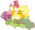
 Prowincje I RP ru.svg 1,047 × 916; 196 KB
-
 Prowincje I RP-uk.svg 1,047 × 916; 195 KB
-
 Prowincje I RP-variante de.svg 855 × 744; 345 KB
-
 Prowincje I RP.svg 1,047 × 916; 191 KB


.svg)


