Category:SVG maps of the history of Chile
Media in category "SVG maps of the history of Chile"
The following 132 files are in this category, out of 132 total.
-
 1893 border protocol between Argentina & Chile.svg 694 × 589; 916 KB
-
 1902 Andes Boundary Case de.svg 537 × 645; 1.02 MB
-
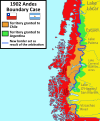 1902 Andes Boundary Case.svg 1,430 × 1,720; 1.47 MB
-
 Acuerdos de Charaña.svg 1,109 × 865; 242 KB
-
 Aguas Blancas comuna 1927.svg 173 × 262; 251 KB
-
 Andacollo comuna 1927.svg 82 × 162; 517 KB
-
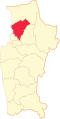
 Antofagasta comuna 1927.svg 173 × 262; 251 KB
-
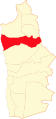
 Antofagasta división comunal 1927.svg 173 × 262; 251 KB
-
 LocationKingdomAraucania.svg 1,000 × 500; 987 KB
-
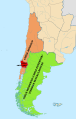
 Argentine and Chilean Antarctic claims (1946–present (as of 2023)).svg 728 × 845; 732 KB
-
 Arica comuna 1928.svg 94 × 199; 156 KB
-
 Arica Department (Chile).png 2,268 × 2,764; 178 KB
-
 Arica Department (Chile).svg 2,268 × 2,764; 146 KB
-
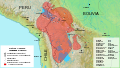
 Atacama Desert Dispute between Bolivia and Chile (1825 - 1879).svg 1,500 × 1,500; 3.41 MB
-
 Aymara-language-domain-en-001.svg 1,278 × 728; 2 MB
-
 Aymara-language-domain-es-001.svg 1,278 × 728; 1.98 MB
-
 Aysén location map (+claims, 1974-1995) Laguna del Desierto included.svg 300 × 397; 1.1 MB
-
 Aysén location map (1974-1995) Laguna del Desierto Disputed.svg 300 × 397; 1.08 MB
-
 Bandera mapa de Chile (Patria Nueva, 1817).svg 1,582 × 3,543; 3.2 MB
-
 Bandera mapa de Chile (Patria Vieja, 1812).svg 1,582 × 3,543; 3.2 MB
-
 Bandera mapa de la Capitanía General de Chile, 1775.svg 1,579 × 3,543; 1.35 MB
-
 Bandera mapa de la Capitanía General de Chile, 1776.svg 1,575 × 3,543; 3.19 MB
-
 Bandera mapa de la Capitanía General de Chile, 1785.svg 1,582 × 3,543; 3.45 MB
-
 Belén comuna 1928.svg 93 × 198; 121 KB
-
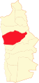
 Calama comuna 1927.svg 173 × 262; 251 KB
-
 Capitanía General de Chile, 1775, mapa satelital.svg 1,710 × 2,684; 8.84 MB
-
 Capitanía General de Chile, 1775.svg 1,710 × 2,684; 4.53 MB
-
 Capitanía General de Chile, 1776.svg 1,710 × 2,684; 4.77 MB
-
 Capitanía General de Chile, 1810 (Uti possidetis iuris).svg 1,710 × 2,684; 5.8 MB
-
 Captaincy General of Chile, 1775.svg 1,710 × 2,684; 4.5 MB
-
 Capture of Valdivia-es.svg 797 × 510; 102 KB
-
 Catalina comuna 1927.svg 173 × 262; 251 KB
-
 Chile disputed w1 countrymap.svg 1,000 × 1,000; 30 KB
-
 Chile location map (+claims until 1994).svg 1,183 × 2,658; 975 KB
-
 Chile location map (+claims, 1775).svg 1,710 × 2,679; 2.2 MB
-
 Chile location map (+claims, 1776).svg 1,710 × 2,679; 3.06 MB
-
 Chile location map (+claims, 1818).svg 1,710 × 2,679; 3.31 MB
-
 Chile location map (+claims, 1825).svg 1,710 × 2,679; 3.32 MB
-
 Chile location map (+claims, 1850).svg 1,710 × 2,679; 3.34 MB
-
 Chile location map (+claims, 1865).svg 1,710 × 2,679; 3.35 MB
-
 Chile location map (+claims, 1866).svg 1,710 × 2,679; 3.1 MB
-
 Chile location map (+claims, 1881).svg 1,710 × 2,679; 3.29 MB
-
 Chile location map (+claims, 1899).svg 1,183 × 2,679; 1.19 MB
-
 Chile location map (+claims, 1900).svg 1,183 × 2,679; 1.04 MB
-
 Chile location map (+claims, 1903).svg 1,183 × 2,679; 1.01 MB
-
 Chile location map (+claims, 1904).svg 1,183 × 2,679; 1 MB
-
 Chile location map (1818).svg 1,710 × 2,679; 4.58 MB
-
 Chile location map (1884-1929).svg 1,474 × 2,775; 439 KB
-
 Chilean Central Valley (Historical).svg 300 × 570; 75 KB
-
 Codpa comuna 1928.svg 93 × 198; 121 KB
-
 Combarbalá comuna 1927.svg 82 × 162; 517 KB
-
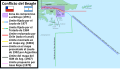 Conflicto del Beagle.svg 1,355 × 772; 1.9 MB
-
 Coquimbo comuna 1927.svg 82 × 162; 517 KB
-
 Coquimbo división comunal 1927.svg 82 × 162; 517 KB
-
 Corregimiento de Copiapó en la Capitanía General de Chile.svg 1,710 × 2,679; 2.26 MB
-
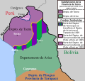
 Cuestión de Tacna y Arica.svg 3,954 × 3,837; 1.03 MB
-
 Cuyo en la Capitanía General de Chile.svg 1,710 × 2,679; 2.53 MB
-
 Departamento de Arica, Chile.svg 3,093 × 2,937; 787 KB
-
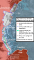
 Disputa antártica entre Argentina y Chile (1946-presente).svg 728 × 845; 740 KB
-
 Disputa de la Laguna del Desierto.svg 1,205 × 1,063; 2.62 MB
-

-
 Disputa limítrofe de Alto Palena.svg 1,772 × 2,776; 1.29 MB
-
 Disputa limítrofe del desierto de Atacama entre Bolivia y Chile (1825 - 1879).svg 1,500 × 1,500; 3.5 MB
-

-
 Establecimientos del Imperio español en la Patagonia atlántica.svg 570 × 958; 4.31 MB
-
 Flag map of Chile, 1818.svg 1,582 × 3,543; 2.84 MB
-
 Flag map of Chile, 1881.svg 1,517 × 3,780; 1.75 MB
-
 General Lagos comuna 1928.svg 94 × 199; 156 KB
-
 Huara comuna 1928.svg 94 × 199; 156 KB
-
 Illapel comuna 1927.svg 82 × 162; 517 KB
-
 Iquique comuna 1928.svg 94 × 199; 156 KB
-
 La Higuera comuna 1927.svg 82 × 162; 517 KB
-
 La Serena comuna 1927.svg 82 × 162; 517 KB
-
 Laguna del Desierto dispute.svg 1,205 × 1,063; 2.65 MB
-
 Lagunas comuna 1928.svg 93 × 198; 120 KB
-
 Laudo limítrofe entre Argentina y Chile de 1902.svg 1,430 × 1,720; 1.51 MB
-
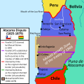
 Litigio de la Puna de Atacama.svg 414 × 491; 677 KB
-
 Los Vilos comuna 1927.svg 82 × 162; 517 KB
-
 Límites Campo de Hielo Patagónico Sur antes de 1994.svg 935 × 1,641; 2.62 MB
-
 Límites Campo de Hielo Patagónico Sur.svg 935 × 1,641; 2.73 MB
-
 Macro regiones del reino de Chile.svg 1,710 × 2,679; 2.63 MB
-
 Magallanes y Antártica Chilena location map (South American part) (+claims, 1974).svg 1,535 × 1,550; 1.15 MB
-
 Mapa de Chile (1928).svg 400 × 2,000; 1.32 MB
-
 Mapa de Chile (1928, provincias).svg 400 × 2,000; 935 KB
-
 Mapa de Chile (1929).svg 400 × 2,000; 1.3 MB
-
 Mapa de Chile (1929, provincias).svg 400 × 2,000; 923 KB
-
 Mejillones comuna 1927.svg 173 × 262; 251 KB
-
 Mincha comuna 1927.svg 82 × 162; 518 KB
-
 Monte Patria comuna 1927.svg 82 × 162; 518 KB
-
 Negreiros comuna 1928.svg 93 × 198; 120 KB
-
 Ovalle comuna 1927.svg 82 × 162; 518 KB
-
 Paiguano comuna 1927.svg 82 × 162; 518 KB
-
 Parte sudamericana del Reino de Chile, 1776.svg 1,576 × 3,543; 833 KB
-
 Pica comuna 1928.svg 93 × 198; 120 KB
-
 Pisagua comuna 1928.svg 93 × 198; 120 KB
-
 Pozo Almonte comuna 1928.svg 93 × 198; 120 KB
-
 Protocolo de límites de 1893 entre Argentina y Chile.svg 694 × 589; 929 KB
-
 Provincia de Tacna, Chile (1884-1925).svg 2,268 × 2,764; 285 KB
-
 Provincia de Tacna, Chile (1925-1929).svg 2,268 × 2,764; 252 KB
-
 Pueblos indigenas de Chile 2.svg 559 × 1,064; 1.28 MB
-
 Pueblos indigenas de Chile-ver.svg 820 × 2,721; 1.23 MB
-
 Pueblos indigenas de Chile.svg 3,000 × 835; 1.29 MB
-
 Pueblos indígenas de la Patagonia Austral.svg 1,535 × 1,550; 881 KB
-
 Puna de Atacama dispute.svg 414 × 491; 649 KB
-
 Punitaqui comuna 1927.svg 82 × 162; 518 KB
-
 Putre comuna 1928.svg 93 × 198; 120 KB
-
 Pérdidas territoriales de iure de la República de Chile.svg 1,800 × 2,808; 3.84 MB
-
 Resultados Plebiscito 1988 por comuna.svg 400 × 2,000; 2.73 MB
-
 Resultados Plebiscito 1988 por provincia.svg 400 × 2,000; 1.13 MB
-
 Resultados Plebiscito 1988 por región.svg 400 × 2,000; 961 KB
-
 Salamanca comuna 1927.svg 82 × 162; 518 KB
-
 Samo Alto comuna 1927.svg 82 × 162; 518 KB
-
 Sierra Gorda comuna 1927.svg 173 × 262; 251 KB
-
 Southern Patagonian Ice Field border.svg 935 × 1,641; 2.64 MB
-
 Southern Patagonian Ice Field dispute before 1994.svg 935 × 1,641; 2.45 MB
-
 Tacna Department (Chile) (1884-1911).svg 2,268 × 2,764; 121 KB
-
 Tacna Department (Chile).png 2,268 × 2,764; 178 KB
-
 Tacna Department (Chile).svg 2,268 × 2,764; 146 KB
-
 Tacna province (1884-1925) Chile location map.svg 2,268 × 2,764; 146 KB
-
 Tacna province (1925-1929) Chile location map.svg 2,268 × 2,764; 80 KB
-
 Tacna-Arica Dispute (1883-1929).svg 3,954 × 3,837; 1 MB
-
 Taltal comuna 1927.svg 173 × 262; 251 KB
-
 Tarapacá antigua división por comunas 1928.svg 93 × 198; 120 KB
-
 Tarata Department (Chile).png 2,268 × 2,764; 194 KB
-
 Tarata Department (Chile).svg 2,268 × 2,764; 146 KB
-
 Territorial losses of the Republic of Chile de jure.svg 1,800 × 2,808; 3.75 MB
-
 Toco comuna 1927.svg 173 × 262; 251 KB
-
 Tocopilla comuna 1927.svg 173 × 262; 251 KB
-
 Tratado de Ancón.svg 4,591 × 6,024; 547 KB
-
 Treaty of Ancón.svg 4,606 × 6,024; 513 KB
-
 Vicuña comuna 1927.svg 82 × 162; 518 KB
-
 アルゼンチンとチリの南極請求(1946年~現在(2023年時点)).svg 512 × 594; 603 KB


).svg)

.png)
.svg)
.svg)


_Laguna_del_Desierto_included.svg)
_Laguna_del_Desierto_Disputed.svg)
.svg)
.svg)


.svg)


.svg)
.svg)
.svg)
.svg)
.svg)
.svg)
.svg)
.svg)
.svg)
.svg)
.svg)
.svg)
.svg)
.svg)
.svg)
.svg)


.svg)

.svg)

.svg)
.svg)


_(%2Bclaims,_1974).svg)


.svg)
.svg)


_(1884-1911).svg)
.png)
.svg)
_Chile_location_map.svg)
_Chile_location_map.svg)
.svg)


.png)
.svg)


.svg)
.svg)
.svg)
.svg)