Category:SVG maps of the history of India
Media in category "SVG maps of the history of India"
The following 63 files are in this category, out of 63 total.
-
 Agra 1631.svg 572 × 450; 180 KB
-
 British Raj-es.svg 1,201 × 1,007; 176 KB
-
 British Raj.svg 1,201 × 1,007; 221 KB
-
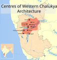 Centres of Western Chalukya architecture map.svg 385 × 404; 529 KB
-
 Chola Empire map corrected-01.svg 512 × 366; 328 KB
-
 Dispartigo de Barato 1947.svg 1,189 × 1,170; 223 KB
-
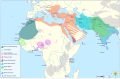
 Hinduism Expansion in Asia de.svg 1,060 × 791; 845 KB
-
 Hinduism Expansion in Asia-es.svg 512 × 382; 1.28 MB
-
 Hinduism Expansion in Asia-hu.svg 512 × 382; 824 KB
-
 Hinduism Expansion in Asia-id.svg 512 × 382; 779 KB
-
 Hinduism Expansion in Asia-pt.svg 512 × 382; 826 KB
-
 Hinduism Expansion in Asia-zh-hans.svg 512 × 382; 779 KB
-
 Hinduism Expansion in Asia.svg 512 × 382; 769 KB
-
 Hoysala Empire extent.svg 1,486 × 1,734; 423 KB
-
 Hoysala kingdom (blank).svg 349 × 435; 3.09 MB
-
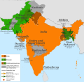
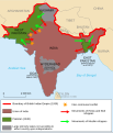
 India disputed areas map.svg 1,639 × 1,852; 978 KB
-
 India in 1525 Joppen-es.svg 1,883 × 2,222; 1.65 MB
-
 India in 1605-es.svg 1,883 × 2,222; 1.47 MB
-
 Indian Kanauj triangle map-es.svg 1,539 × 1,735; 1.8 MB
-
 Indian Kanauj triangle map.svg 1,639 × 1,852; 389 KB
-
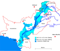 Indus flooding 2010 en.svg 856 × 726; 702 KB
-
 Map of Danish Settlements in India (1620 - 1845).svg 512 × 446; 162 KB
-
 Map of the MENA region in 1798.svg 1,543 × 1,006; 528 KB
-
 Mauryas map.svg 3,099 × 2,868; 7.09 MB
-
 NEFA 1961 as.svg 862 × 677; 760 KB
-
 NEFA 1961.svg 862 × 677; 759 KB
-
 Partage de l'Inde.svg 718 × 838; 32 KB
-
 Partition of India 1947 en.svg 1,189 × 1,170; 724 KB
-
 Partition of India 1947 es.svg 1,189 × 1,170; 215 KB
-
 Partition of India 1947 fr.svg 1,189 × 1,170; 461 KB
-
 Partition of India 1947 gu.svg 1,189 × 1,170; 222 KB
-
 Partition of India 1947 it.svg 1,189 × 1,170; 162 KB
-
 Partition of India 1947 mr.svg 1,189 × 1,170; 219 KB
-
 Partition of India 1947-bn.svg 1,189 × 1,170; 231 KB
-
 Partition of India 1947-hu.svg 1,189 × 1,170; 253 KB
-
 Partition of India 1947-kn.svg 1,189 × 1,170; 229 KB
-
 Partition of India 1947-pa.svg 1,189 × 1,170; 216 KB
-
 Partition of India-bn (1947).svg 718 × 838; 53 KB
-
 Partition of India-ce.svg 718 × 838; 46 KB
-
 Partition of India-en.svg 718 × 838; 44 KB
-
 Partition of India-es.svg 718 × 838; 53 KB
-
 Partition of India-fa.svg 718 × 838; 54 KB
-
 Partition of India-ms.svg 718 × 838; 53 KB
-
 Partition of India-ru.svg 718 × 838; 45 KB
-
 Partition of India-sd.svg 718 × 838; 59 KB
-
 Partition of India-ur.svg 718 × 838; 54 KB
-
 Partizione dell'India.svg 718 × 838; 32 KB
-
 Punjab 1951-66.svg 1,055 × 427; 50 KB
-
 Rashtrakuta-empire-map.svg 1,510 × 1,753; 428 KB
-
 Shaka Satavahana Maps.svg 1,574 × 1,738; 1.22 MB
-
 South Asia historical AD375 EN.svg 1,300 × 1,260; 775 KB
-
 South Asia historical AD375 es.svg 1,300 × 1,260; 442 KB
-
 South Asia historical AD375 NL.svg 1,300 × 1,260; 791 KB
-
 South Asia historical AD450 EN.svg 1,330 × 1,250; 769 KB
-
 South Asia historical AD450 es.svg 1,330 × 1,250; 425 KB
-
 South Asia historical AD550 NL.svg 1,280 × 1,250; 778 KB
-
 South Asia historical AD590 NL.svg 1,260 × 1,380; 839 KB
-
 South Asia historical AD625 EN.svg 1,275 × 1,380; 861 KB
-
 South Asia historical AD625 es.svg 1,275 × 1,380; 495 KB
-
 South Asia historical AD625 NL.svg 1,275 × 1,380; 846 KB
-
 South Asia historical AD625 ZH HANS.svg 1,275 × 1,380; 256 KB
-
 South Asia historical AD625 ZH HANT.svg 1,275 × 1,380; 253 KB
-
 South Indian territories de.svg 693 × 748; 697 KB


.svg)


.svg)


.svg)