Category:SVG political maps of France

Subcategories
This category has the following 8 subcategories, out of 8 total.
Media in category "SVG political maps of France"
The following 44 files are in this category, out of 44 total.
-
 2015 French departmental elections - First round leading party.svg 530 × 550; 221 KB
-
 Caribbean maritime boundaries map zh.svg 3,561 × 2,221; 2.87 MB
-
 Caribbean maritime boundaries map.svg 3,561 × 2,221; 2.78 MB
-
 Caribbean maritime boundaries map mk.svg 3,561 × 2,221; 5.52 MB
-
 Mapa das Caraíbas (fronteiras marítimas).svg 3,561 × 2,221; 2.86 MB
-
 Mapa del Caribe (límites marinos).svg 5,340 × 3,660; 3.02 MB
-
 Mapa del Mar Caribe (límites marinos)-fr.svg 3,587 × 2,221; 1.91 MB
-
 Mapa del Mar Caribe (límites marinos).svg 3,587 × 2,221; 1.98 MB
-
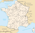
 Carte régionale - Noms des régions.svg 1,000 × 960; 390 KB
-
 Cartogramme abstention régionales 2015 tour 1 par canton.png 807 × 666; 326 KB
-
 Cartogramme résultats régionales 2015 tour 1 par canton.svg 807 × 771; 10.52 MB
-
 Cartogramme vote blanc régionales 2015 tour 1 par canton.png 779 × 680; 344 KB
-
 Cartogramme vote blanc régionales 2015 tour 1 par canton.svg 779 × 680; 11.27 MB
-
 Departamentos e rexións de Francia.svg 606 × 555; 353 KB
-
 Departements+regions (França 2017).svg 576 × 551; 417 KB
-
 Départements et régions de France - Noname eu.svg 588 × 550; 406 KB
-
 Départements et régions de France - Noname-2014.svg 588 × 550; 437 KB
-
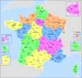
 Départements et régions de France - Noname-2016.svg 588 × 550; 405 KB
-
 Départements et régions de France eo.svg 588 × 550; 465 KB
-
 Départements et régions de France es.svg 588 × 550; 437 KB
-
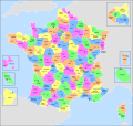
 Départements et régions de France.svg 588 × 550; 438 KB
-
 Départements+régions (France)-af.svg 588 × 550; 476 KB
-
 Départements+régions (France)bleu.svg 588 × 550; 477 KB
-
 Départements+régions (France)jaune.svg 588 × 550; 477 KB
-
 Départements+régions (France)rouge.svg 588 × 550; 477 KB
-
 Départements+régions (France)vert.svg 588 × 550; 477 KB
-
 Députés sortants de France en 2017.svg 1,456 × 1,655; 2.15 MB
-
 FR-Aviation.svg 463 × 436; 412 KB
-
 FR-Departements-collect-statut-part.svg 512 × 483; 310 KB
-
 FR-Douanes.svg 463 × 436; 371 KB
-
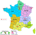
 FR-Régions.svg 463 × 436; 354 KB
-
 FR-Zones-de-Défense.svg 463 × 436; 301 KB
-
 France départementale frp.svg 2,000 × 1,898; 4.55 MB
-
 France départementale.svg 2,000 × 1,898; 1.87 MB
-
 France maximale 2016.svg 2,000 × 1,898; 4.82 MB
-
 France régionale brezhoneg Rannvroioù eus Frañs.svg 2,000 × 1,898; 4.35 MB
-
 France régionale Oc Region francesa.svg 2,000 × 1,898; 4.55 MB
-
 France régionale.svg 2,000 × 1,898; 4.55 MB
-
 France Uzbekistan Locator.svg 940 × 477; 1.56 MB
-
 Incumbent deputies of France 2017.svg 1,464 × 1,655; 2.08 MB
-
 Locator map of France.svg 680 × 520; 660 KB
-
 Referendum in Frankreich 1969.svg 714 × 687; 200 KB
-
 Regiones metropolitanas de Francia.svg 606 × 555; 353 KB
-
 Territorial waters - France.svg 800 × 400; 722 KB


.svg)
.svg)
-fr.svg)
.svg)


.svg)


-af.svg)
bleu.svg)
jaune.svg)
rouge.svg)
vert.svg)


