Category:Saint Andrew Church (Draßmarkt)
| Object location | | View all coordinates using: OpenStreetMap |
|---|
| This category shows the protected monument with the number 49696 in Austria. (Commons, de, Wikidata) |
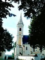
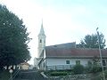
cemetery in Draßmarkt, Austria .JPG) Pfarrkirche hl. Andreas in Draßmarkt | |||||
| Upload media | |||||
| Instance of | |||||
|---|---|---|---|---|---|
| Named after | |||||
| Location | Draßmarkt, Oberpullendorf District, Burgenland, Austria | ||||
| Street address |
| ||||
| Heritage designation | |||||
 | |||||
Subcategories
This category has only the following subcategory.
Media in category "Saint Andrew Church (Draßmarkt)"
The following 11 files are in this category, out of 11 total.
-
 Derecske 032.jpg 960 × 1,280; 269 KB
-
 Derecske 038.jpg 1,280 × 960; 191 KB
-
 Draßmarkt - Kirche (1).JPG 3,484 × 2,865; 9.91 MB
-
 Draßmarkt - Kirche (2).JPG 4,134 × 3,504; 9.93 MB
-
 Kirche drassmarkt.JPG 2,736 × 3,648; 2.12 MB
-
 Saint Andrew Church Draßmarkt 01.jpg 3,823 × 5,734; 6.89 MB
-
 Saint Andrew Church Draßmarkt 02.jpg 3,558 × 5,336; 6.04 MB
-
 Saint Andrew Church Draßmarkt 03.jpg 3,606 × 5,409; 6.34 MB
-
 Saint Andrew Church Draßmarkt 04.jpg 5,647 × 3,765; 7.8 MB
-
 Saint Andrew Church Draßmarkt 05.jpg 4,000 × 6,000; 9.59 MB
-
 Saint Andrew Church Draßmarkt 06.jpg 3,578 × 5,366; 5.98 MB


.JPG)


