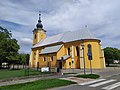
Category:Saint Ladislas church, Mojmírovce
| Object location | | View all coordinates using: OpenStreetMap |
|---|
| This category shows the protected monument with the number 403-1470/0 (other) in the Slovak Republic. |
Slovenčina: Rímskokatolícky farský kostol sv. Ladislava v Mojmírovciach, okres Nitra
Media in category "Saint Ladislas church, Mojmírovce"
The following 5 files are in this category, out of 5 total.
-
 Mojmirovce kostol.jpg 1,600 × 1,200; 570 KB
-
 Mojmírovce kostol 01.jpg 4,000 × 3,000; 4.53 MB
-
 Mojmírovce kostol 02.jpg 3,000 × 4,000; 1.55 MB
-
 Ürmény templom 1.JPG 2,272 × 1,704; 2.23 MB
-
 Ürmény templom 2.JPG 2,272 × 1,704; 1.95 MB


