This category shows the protected monument with the number 55093 in Austria. (Commons, de, Wikidata)
<nowiki>Parish church of Saint Leonard (Münchendorf); Pfarrkirche Münchendorf (Hl. Leonhard); église paroissiale Saint-Léonard de Münchendorf; Pfarrkirche Münchendorf (Hl. Leonhard); roman-catholic parish church in Münchendorf, Lower Austria; église paroissiale catholique romaine autrichienne; römisch-katholische Pfarrkirche in Münchendorf, Niederösterreich (55093); römisch-katholische Pfarrkirche in Münchendorf, Niederösterreich (55093); Kath. Pfarrkirche Hl. Leonhard und ehem. Friedhofsfläche samt Ummauerung; Kath. Pfarrkirche Hl. Leonhard und ehem. Friedhofsfläche samt Ummauerung</nowiki>
Parish church of Saint Leonard (Münchendorf)
roman-catholic parish church in Münchendorf, Lower Austria


 Münchendorf 8451.jpg 2,592 × 3,888; 589 KB
 Münchendorf Kirche 2.JPG 1,313 × 1,969; 1.98 MB
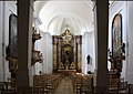 Münchendorf Kirche Innenansicht.JPG 2,362 × 1,673; 3.87 MB
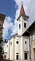 Münchendorf Kirche.JPG 907 × 1,575; 1.2 MB
 Münchendorf PK 112.JPG 3,000 × 4,000; 4 MB
 Münchendorf PK 113.JPG 3,000 × 4,000; 3.97 MB
 Münchendorf PK 114.JPG 3,000 × 4,000; 4.3 MB
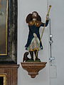 Münchendorf PK 115.JPG 3,000 × 4,000; 4.51 MB
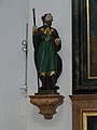 Münchendorf PK 116.JPG 3,000 × 4,000; 4.31 MB
 Münchendorf PK 117.JPG 3,000 × 4,000; 4.55 MB
 Münchendorf PK Seitenaltar 109.JPG 4,000 × 3,000; 4.68 MB
 Münchendorf PK Seitenaltar 110.JPG 4,000 × 3,000; 4.69 MB


