Category:Saint Maurice Church (Aurolzmünster)
| Object location | | View all coordinates using: OpenStreetMap |
|---|
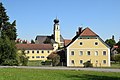
church building in Aurolzmünster, Austria .JPG) Pfarrkirche hl. Mauritius in Aurolzmünster | |||||
| Upload media | |||||
| Instance of | |||||
|---|---|---|---|---|---|
| Named after | |||||
| Location | Aurolzmünster, Ried District, Upper Austria, Austria | ||||
| Heritage designation | |||||
 | |||||
Subcategories
This category has only the following subcategory.
Media in category "Saint Maurice Church (Aurolzmünster)"
The following 8 files are in this category, out of 8 total.
-
 Aurolzmünster - Kirche (1).JPG 4,276 × 3,010; 9.88 MB
-
 Aurolzmünster - Kirche (2).JPG 3,803 × 2,988; 9.81 MB
-
 Aurolzmünster - Pfarrhof u Pfarrkirche S.jpg 1,882 × 1,254; 2.01 MB
-
 Aurolzmünster - Pfarrkirche Hl. Mauritius - Hauptfront.jpg 3,648 × 2,736; 2.52 MB
-
 Aurolzmünster - Pfarrkirche Hl. Mauritius - Seitenportale.jpg 3,000 × 1,800; 1.9 MB
-
 Aurolzmünster - Pfarrkirche Hl. Mauritius - Wappengrabsteine.jpg 3,000 × 1,500; 2.43 MB
-

-
 Pfarrkirche Aurolzmünster.gif 300 × 229; 52 KB
.JPG)


