Category:Saint Stanislaus church in Pruśce
| Object location | | View all coordinates using: OpenStreetMap |
|---|
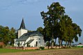
Polski: Pruśce - kościół parafialny p.w. św. Stanisława BM (1870):
cmentarz, grobowiec rodziny Szułdrzyńskich, 1904:
plebania, poł. XIX (osobna kategoria poniżej):
church building in Pruśce, Poland  | |||||
| Upload media | |||||
| Instance of | |||||
|---|---|---|---|---|---|
| Location | Pruśce, Gmina Rogoźno, Oborniki County, Greater Poland Voivodeship, Poland | ||||
| Heritage designation |
| ||||
| Inception |
| ||||
 | |||||
Media in category "Saint Stanislaus church in Pruśce"
The following 8 files are in this category, out of 8 total.
-
 Kościół parafialny w Pruścach 02.jpg 1,534 × 1,020; 928 KB
-
 Pruśce, Kościół Parafialny pw. św. Stanisława z 1870 r.jpeg 4,928 × 3,264; 2.34 MB
-
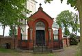 Grobowiec Szułdrzyńskich w Pruścach 01.JPG 2,146 × 1,470; 1.51 MB
-
 Kościół parafialny w Pruścach 01.jpg 1,534 × 1,020; 1,019 KB
-
 Prusce - Grobowiec Szułdrzyńskich 01.jpg 3,845 × 2,525; 2.17 MB
-
 Prusce Grobowiec Szułdrzyńskich.jpg 3,195 × 2,533; 1.99 MB
-
 Prusce Kościół św. Stanisława 1.jpg 3,795 × 2,513; 2.35 MB
-
 Zespół koscioła pw. św. Stanisława w Pruścach.jpg 3,563 × 2,505; 2.26 MB


