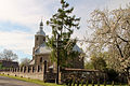
Category:Saint Thecla church in Wódka
| Object location | | View all coordinates using: OpenStreetMap |
|---|
church building in Wódka, Opole Voivodeship, Poland  | |||||
| Upload media | |||||
| Instance of | |||||
|---|---|---|---|---|---|
| Location | Wódka, Gmina Branice, Głubczyce County, Opole Voivodeship, Poland | ||||
| Heritage designation |
| ||||
| Inception |
| ||||
 | |||||
Polski: Wódka - rzymskokatolicki kościół parafialny pw. św. Tekli, 1772
Media in category "Saint Thecla church in Wódka"
The following 3 files are in this category, out of 3 total.
-
 2012-04 Wódka 09.jpg 2,541 × 3,810; 3.86 MB
-
 2012-04 Wódka 08.jpg 4,163 × 2,775; 4.3 MB
-
 2012-04 Wódka 10.jpg 3,418 × 4,539; 4.53 MB

