Category:Sainte-Marie (Münster)
| Object location | | View all coordinates using: OpenStreetMap |
|---|
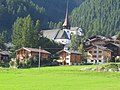
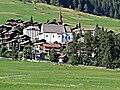
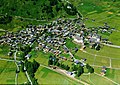
church buildings in Münster in the canton of Goms, Switzerland  | |||||
| Upload media | |||||
| Instance of | |||||
|---|---|---|---|---|---|
| Part of | |||||
| Location | Münster, Goms, Goms District, Valais, Switzerland | ||||
| Street address |
| ||||
| Heritage designation | |||||
 | |||||
Media in category "Sainte-Marie (Münster)"
The following 8 files are in this category, out of 8 total.
-
 ETH-BIB-Kirche Münster, Goms, Inneres-Dia 247-03266.tif 3,428 × 2,818; 27.75 MB
-
 ETH-BIB-Münster, Goms-LBS H1-018969.tif 6,730 × 4,715; 90.89 MB
-
 Kirche St. Maria Münster VS.jpg 1,200 × 1,600; 413 KB
-
 Munster - Église Sainte-Marie.jpg 4,032 × 4,827; 16.29 MB
-
 Münster Goms VS.JPG 2,816 × 2,112; 1.53 MB
-
 Münster Kirche.JPG 2,816 × 2,112; 4.38 MB
-
 Münster VS 1983 Com FC22-3985-001.jpg 3,371 × 2,387; 3.65 MB
-
 Münster-Geschinen - Kirche St. Maria.JPG 2,000 × 3,008; 2.62 MB


