Category:San Pablo Avenue
English: San Pablo Avenue — designated California State Route 123, in the East Bay Region, northern California.
- The major street is located in Alameda County and western Contra Costa County.
Media in category "San Pablo Avenue"
The following 20 files are in this category, out of 20 total.
-
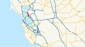 California State Route 123.svg 1,152 × 640; 394 KB
-
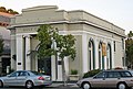 Bank of Pinole (Pinole, CA).JPG 1,373 × 931; 340 KB
-
 Berkeley Free Clinic truck offering free HIV tests.jpg 3,847 × 2,884; 2.56 MB
-
 CA123-CA13.jpg 300 × 841; 61 KB
-
 California Hotel (Oakland, CA).JPG 1,406 × 1,198; 635 KB
-
 Cerrito Theater San Pablo Avenue (cropped).jpg 3,046 × 1,863; 2.52 MB
-
 Cerrito Theater San Pablo Avenue.jpg 4,128 × 2,752; 4.46 MB
-
 El Cerrito del Norte BART station from West.jpeg 2,560 × 1,920; 872 KB
-
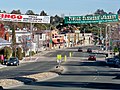
 Golden Gate shopping district concrete bollard sign.jpg 2,816 × 2,112; 2.59 MB
-
 Googled222.jpg 1,944 × 2,592; 684 KB
-
 Klinknerville Real Estate Banner c1890.jpeg 3,975 × 2,839; 2.18 MB
-
 Love Our Neighborhood Day 2014 San Pablo Avenue.jpg 4,320 × 3,240; 5.67 MB
-
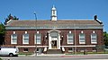 Oakland Free Library-Golden Gate Branch (Oakland, CA).JPG 1,586 × 885; 433 KB
-
 Pacific Gas & Electric Company Building (Oakland, CA).JPG 1,145 × 1,597; 592 KB
-
 San Pablo AveNorth.JPG 2,592 × 1,944; 1.57 MB
-
 Sanpab-n-mac.jpg 2,211 × 1,656; 382 KB
-
 Shipyard Railway track construction on San Pablo Avenue, 1942 (descreen + curves).jpg 2,491 × 1,616; 600 KB
-
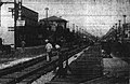 Shipyard Railway track construction on San Pablo Avenue, 1942.jpg 2,491 × 1,616; 703 KB
-
 Welcome Sign San Pablo California.jpg 3,672 × 2,448; 3.69 MB
-
 YBMB1.jpg 800 × 696; 425 KB

.JPG)

.JPG)
.jpg)


.JPG)
.JPG)


.jpg)


