Category:Sanborn Fire Insurance Map from Corning, Clay County, Arkansas
Media in category "Sanborn Fire Insurance Map from Corning, Clay County, Arkansas"
The following 11 files are in this category, out of 11 total.
-
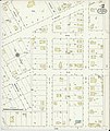
 Sanborn Fire Insurance Map from Corning, Clay County, Arkansas. LOC sanborn00222 001-1.jpg 6,450 × 7,650; 3.36 MB
-
 Sanborn Fire Insurance Map from Corning, Clay County, Arkansas. LOC sanborn00222 001-2.jpg 6,450 × 7,650; 3.21 MB
-
 Sanborn Fire Insurance Map from Corning, Clay County, Arkansas. LOC sanborn00222 001-3.jpg 6,450 × 7,650; 3.12 MB
-
 Sanborn Fire Insurance Map from Corning, Clay County, Arkansas. LOC sanborn00222 001-4.jpg 6,450 × 7,650; 3.23 MB
-
 Sanborn Fire Insurance Map from Corning, Clay County, Arkansas. LOC sanborn00222 002-1.jpg 6,450 × 7,650; 3.67 MB
-
 Sanborn Fire Insurance Map from Corning, Clay County, Arkansas. LOC sanborn00222 002-2.jpg 6,450 × 7,650; 3.07 MB
-
 Sanborn Fire Insurance Map from Corning, Clay County, Arkansas. LOC sanborn00222 002-3.jpg 6,450 × 7,650; 3.36 MB
-
 Sanborn Fire Insurance Map from Corning, Clay County, Arkansas. LOC sanborn00222 002-4.jpg 6,450 × 7,650; 3.38 MB
-
 Sanborn Fire Insurance Map from Corning, Clay County, Arkansas. LOC sanborn00222 002-5.jpg 6,450 × 7,650; 3.21 MB
-
 Sanborn Fire Insurance Map from Corning, Clay County, Arkansas. LOC sanborn00222 002-6.jpg 6,450 × 7,650; 2.99 MB
-
 Sanborn Fire Insurance Map from Corning, Clay County, Arkansas. LOC sanborn00222 002-7.jpg 6,450 × 7,650; 2.94 MB


