Category:Sanborn Fire Insurance Map from Girard, Crawford County, Kansas, 1912
See parent category for index.
Media in category "Sanborn Fire Insurance Map from Girard, Crawford County, Kansas, 1912"
The following 9 files are in this category, out of 9 total.
-
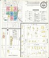 Sanborn Fire Insurance Map from Girard, Crawford County, Kansas, 1912, Plate 0001.jpg 6,450 × 7,650; 3.21 MB
-
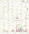
 Sanborn Fire Insurance Map from Girard, Crawford County, Kansas, 1912, Plate 0002.jpg 6,450 × 7,650; 2.29 MB
-
 Sanborn Fire Insurance Map from Girard, Crawford County, Kansas, 1912, Plate 0003.jpg 6,450 × 7,650; 2.6 MB
-
 Sanborn Fire Insurance Map from Girard, Crawford County, Kansas, 1912, Plate 0004.jpg 6,450 × 7,650; 2.27 MB
-
 Sanborn Fire Insurance Map from Girard, Crawford County, Kansas, 1912, Plate 0005.jpg 6,450 × 7,650; 2.37 MB
-
 Sanborn Fire Insurance Map from Girard, Crawford County, Kansas, 1912, Plate 0006.jpg 6,450 × 7,650; 2.54 MB
-
 Sanborn Fire Insurance Map from Girard, Crawford County, Kansas, 1912, Plate 0007.jpg 6,450 × 7,650; 2.62 MB
-
 Sanborn Fire Insurance Map from Girard, Crawford County, Kansas, 1912, Plate 0008.jpg 6,450 × 7,650; 2.24 MB
-
 Sanborn Fire Insurance Map from Girard, Crawford County, Kansas, 1912, Plate 0009.jpg 6,450 × 7,650; 2.3 MB


